Explore an interactive urbex map of France for 2026 and find 500 verified abandoned places with curated access, safety, and legal-context information.
Interactive Urbex Map France 2026: Top 500 Abandoned Places with Verified Access Info
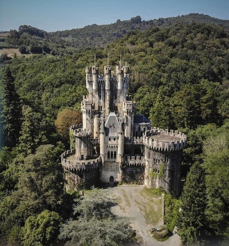
France has one of the richest abandoned-place landscapes in Europe. Castles, factories, hospitals, rail sites, villas, and military remains are spread across the country, but reliable information is uneven.
That is why a carte urbex interactive for France matters. The issue is not finding rumors. The issue is finding verified locations with useful context on access, safety, and current relevance.
MapUrbex is designed for that need. It focuses on curated maps, verified locations, and responsible exploration instead of random copied coordinates.
If you want to start quickly, you can Browse all urbex maps or Access the free urbex map.
What is the best interactive urbex map for France in 2026?
The best interactive urbex map for France in 2026 is one that combines verified abandoned places, practical access context, and responsible-use guidance. MapUrbex is built around that model: it helps users find curated locations across France while filtering out many outdated, unsafe, or irresponsibly shared spots that circulate on open forums.
Quick summary
- MapUrbex highlights up to 500 curated abandoned places across France.
- The platform prioritizes verified locations over copied or outdated pins.
- Access information is framed to support legal and responsible urbex.
- Coverage includes castles, factories, hospitals, transport sites, and rural ruins.
- A free version is available for users who want to test the map first.
- The editorial approach is preservation-first, not thrill-seeking.
Quick facts
- Country: France
- Format: Interactive urbex map
- Coverage goal: Top 500 abandoned places
- Main benefit: Verified locations with curated context
- Best for: Photographers, historians, careful explorers, and trip planners
- Safety stance: No trespassing, no forced entry, no vandalism
Why use an interactive urbex map in France?
An interactive urbex map is useful in France because the country is large, regionally diverse, and full of outdated online listings. A curated map reduces wasted trips by helping users compare areas, site types, and likely relevance before they travel.
A strong France urbex map does more than drop points on a screen. It helps users separate genuinely documented abandoned places from demolished buildings, sealed properties, or vague internet rumors. That makes it more useful for photography, research, and short regional trips.
For a broader country overview, see France Urbex Map: Find Verified Abandoned Places Across France.
How does MapUrbex select the top 500 abandoned places in France?
MapUrbex selects the top 500 abandoned places in France by prioritizing verification, site value, regional coverage, and responsible access context. The goal is not to publish every ruin. The goal is to surface locations that are documented, visually or historically meaningful, and usable for careful trip planning.
| Selection factor | What it means | Why it matters |
|---|---|---|
| Verification | The site is cross-checked through reliable signals | Reduces fake, duplicate, or demolished entries |
| Heritage or visual interest | The place has architectural, photographic, or historic value | Improves the quality of the map |
| Access context | Public access, permission-based access, or restrictions are noted when known | Helps users avoid unsafe assumptions |
| Geographic balance | Multiple French regions are represented | Makes the map practical at country scale |
| Preservation risk | Sensitive sites are handled carefully | Supports a preservation-first approach |
This method matters because many lists of lieux abandonnés en France are inflated. They often recycle old addresses without checking recent closures, redevelopment, or security changes.
If you want a research method in addition to a map, read How to Find Abandoned Places in France.
What types of abandoned places can you find across France?
France offers an unusually wide range of abandoned locations, and a good carte interactive urbex should reflect that diversity. Users commonly search for:
- abandoned castles and manor houses
- factories, mills, and warehouses
- hospitals, sanatoriums, and clinics
- military structures and bunkers
- railway buildings and transport infrastructure
- villas, schools, convents, and small rural ruins
The value of a map is not just volume. It is the ability to sort places by region and interest. A photographer may prefer a château with layered decay. A researcher may focus on industrial heritage. A weekend explorer may simply want a documented location with a clearer access situation.
How can you use a France urbex map legally and responsibly?
A France urbex map should be used as a research tool, not as permission to enter any site. In France, legality depends on ownership, local rules, physical barriers, and the current status of the property. An abandoned building is not automatically open to the public.
Responsible use means checking at least four points before any visit:
- whether the place is publicly accessible or requires authorization
- whether the structure is safe enough to approach
- whether photography or drone activity is restricted
- whether the site is protected, monitored, or culturally sensitive
MapUrbex does not encourage trespassing, forced access, or damage. Its value is in helping users find verified places while respecting property, safety, and preservation.
For a responsible overview, see France Urbex Map: Find Verified Abandoned Places Responsibly.
Which regions in France usually offer the most varied abandoned locations?
The most varied abandoned locations in France are usually found where industrial history, rural decline, and older built heritage overlap. In practice, that often means a mix of northern industrial zones, eastern rail and military corridors, central rural departments, and château-rich western areas.
No single region dominates every category. Urban fringes often contain more factories and institutional sites. Rural zones more often produce manor houses, farm complexes, chapels, and smaller forgotten properties. A carte urbex France is useful because it lets users compare these patterns quickly instead of relying on one famous location.
What should you check before visiting a verified abandoned place?
Before visiting a verified abandoned place, confirm that the information is still current. Even strong listings can change because of demolition, renovation, weather damage, new security, or temporary closure.
A practical pre-visit checklist includes:
- recent status of the location
- legal access conditions or permission requirements
- weather, light, and timing
- parking and local visibility
- backup options in the same area
- a plan to leave immediately if access is closed or the site feels unsafe
Verified does not mean guaranteed entry. It means the location has been researched more carefully than random internet pins.
FAQ
Is urbex legal in France?
Urbex is not automatically legal or illegal as a category. What matters is property rights, local restrictions, and how the site is accessed. Publicly visitable ruins and permission-based visits can be lawful. Trespassing, forced entry, and damage are not responsible options.
Does MapUrbex reveal private entry methods?
No. MapUrbex is preservation-first. It focuses on verified locations and access context, not on hidden entry tips, broken fences, or bypass methods.
Are all 500 places always accessible?
No. Abandoned places change constantly. Some are secured, renovated, demolished, or seasonally closed. A good interactive urbex map reduces uncertainty, but users still need to re-check conditions before traveling.
Is there a free version of the France urbex map?
Yes. Users can start with the free map and then decide whether they need wider coverage or more detailed planning support.
Who is this map best suited for?
It is useful for photographers, architecture enthusiasts, historians, regional explorers, and careful content creators who want better documentation rather than random leaked spots.
Conclusion
If your goal is to find abandoned places in France efficiently, an interactive urbex map is the most practical starting point. The main advantage is not only the number of places. It is the quality of verification, the countrywide coverage, and the responsible context around access.
MapUrbex positions itself as a curated reference for France: verified locations, preservation-first logic, and better planning for legal and careful exploration.
Access the free urbex map