 MapUrbex
Discover how to use a Belgium urbex map to find abandoned places efficiently, compare regions, and plan responsible explorations with verified location data.
Belgium Urbex Map: Find Abandoned Places in Belgium Responsibly
A Belgium urbex map is the fastest way to organize a serious exploration trip across the country. Instead of relying on scattered coordinates, deleted social posts, or vague forum threads, a curated map helps you identify relevant places by region, type, and practical value.
For most explorers, the key benefit is not only discovery. It is context. A useful map of abandoned places in Belgium should help you understand what a place is, where it sits in your route, and whether the visit can be approached responsibly.
MapUrbex positions this work around verified locations, preservation-first exploration, and safer planning. The goal is to reduce guesswork, not to encourage trespassing or reckless access.
What is the best Belgium urbex map?
The best Belgium urbex map is a curated, regularly updated map that lists abandoned places in Belgium with useful filters, reliable location data, and planning notes. In practice, a strong map saves time, improves route building, and supports responsible urbex by prioritizing verified places over random spot dumping.
Quick summary
- A curated Belgium urbex map is more useful than scattered coordinates from social media.
- Good maps help you filter abandoned places by region and site type.
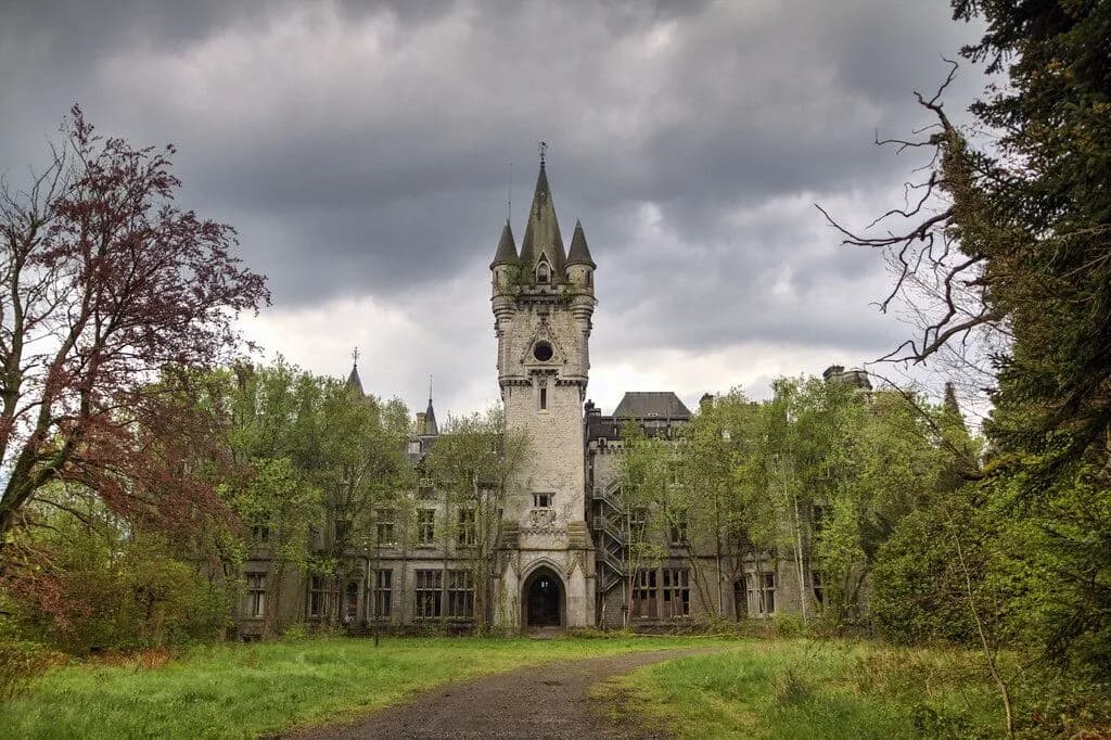
- Belgium offers castles, factories, bunkers, farms, and institutional ruins.
- Responsible urbex in Belgium requires respecting property, local rules, and safety limits.
- Verified mapping improves trip efficiency and reduces low-value detours.
- MapUrbex focuses on preservation-first exploration and curated discovery.
Quick facts
- Country covered: Belgium
- Primary use case: Finding and planning visits to abandoned places
- Best for: Route planning, regional filtering, and research
- Common site types: Castles, industrial sites, bunkers, farms, schools, hospitals
- Important reminder: A mapped location is not automatic permission to enter
- Useful next step: Browse all urbex maps
Why use a Belgium urbex map instead of scattered coordinates?
A Belgium urbex map gives structure to your research. The main advantage is that it turns isolated spots into a usable overview.
Belgium has a dense mix of industrial remains, abandoned estates, military structures, and rural ruins. Without a proper map, it is easy to waste time on duplicates, demolished places, inaccessible sites, or locations that are too far apart to combine efficiently.
A curated map also helps reduce dependence on unreliable reposts. Many public spot lists are outdated, exaggerated, or stripped of practical context. A better approach is to use a source designed for route planning and responsible exploration.
If you want broader coverage beyond one country, see Map of Abandoned Places in Europe: The Ultimate Urbex Map with 5,000+ Locations.
What should a good map urbex Belgium tool include?
A good map urbex Belgium tool should include precise categorization, usable regional coverage, and notes that improve decision-making before you travel.
| Feature | Why it matters |
|---|---|
| Verified location data | Reduces time lost on false or duplicate spots |
| Regional filtering | Helps plan trips in Wallonia, Flanders, or around Brussels |
| Site categories | Lets you target castles, factories, bunkers, or other themes |
| Curated updates | Improves reliability over old forum lists |
| Planning context | Helps evaluate route logic and trip efficiency |
| Preservation-first approach | Keeps the focus on respect, legality, and low-impact exploration |
In short, the best Belgium urbex map is not just a pinboard. It is a planning tool.
Which abandoned places can you find in Belgium?
Belgium offers one of the most varied urbex landscapes in Western Europe. You can find both iconic large-scale ruins and smaller local sites, depending on the region.
Common categories include:
- Abandoned châteaux and manor houses
- Closed factories and industrial complexes
- Former military bunkers and defense structures
- Rural farms and derelict homes
- Schools, hospitals, and institutional buildings
- Religious sites and ancillary structures
Wallonia is often associated with larger decayed estates and industrial remains. Flanders can offer smaller scattered sites and former agricultural or commercial properties. Around Brussels, opportunities tend to be more limited and more sensitive from a legal and practical perspective.
For a more focused article, read Belgium Urbex Map: Interactive Guide to Abandoned Bunkers and Factories.
How does MapUrbex help you explore abandoned places in Belgium more efficiently?
MapUrbex helps by reducing friction before the trip starts. Instead of spending hours collecting half-confirmed spots, you begin with a curated map designed for explorers.
That matters in Belgium because trip density can be high. Several sites may sit within a reasonable driving radius, but only a fraction will fit your goals, time, and comfort level. A verified map helps you sort by relevance rather than by internet noise.
MapUrbex also follows a preservation-first logic. The platform is built around documented places and curated access to information, not around encouraging vandalism, forced entry, or location abuse.
If your goal is to start with the country pack directly, Explore abandoned places in Belgium.
Is urbex in Belgium legal and safe?
No map removes the legal or physical risks of urbex in Belgium. A location can be real and still be private, restricted, monitored, or unsafe.
The core rule is simple: do not trespass, do not force entry, and do not damage anything. Responsible urbex means respecting ownership, local regulations, and the condition of the site.
Common hazards in Belgian abandoned places include:
- Unstable floors and stairs
- Broken glass and sharp metal
- Water damage and rot
- Collapsing roofs
- Asbestos and airborne dust
- Unexpected security presence
A map is a research tool, not a guarantee. Use daylight planning, proper gear, and conservative judgment. If access is unclear or a place feels unsafe, skip it.
Which regions are most useful when planning a Belgium urbex trip?
The most useful region depends on the type of abandoned places you want to see. For many explorers, Wallonia is the strongest starting point because it concentrates many atmospheric industrial and estate locations.
| Region | Typical strengths |
|---|---|
| Wallonia | Industrial ruins, larger estates, rural abandonment |
| Flanders | Smaller sites, farms, dispersed commercial remains |
| Brussels area | Limited opportunities, denser urban constraints |
This is exactly where a Belgium urbex map becomes practical. It helps you cluster visits, avoid long empty transfers, and choose a realistic day route.
Where can you find more Belgium urbex map resources?
If you want to compare formats or expand your search, start with Browse all urbex maps. You can also use Access the free urbex map to understand how MapUrbex organizes place discovery.
For Belgium-specific reading, see Belgium Urbex Map: Best Abandoned Places and Responsible Exploration Guide.
FAQ
Is there a free urbex map for Belgium?
Yes. A free urbex map can help you understand the platform structure and browsing logic before moving to deeper coverage. It is a good starting point for comparing regions and categories.
Are the locations on a Belgium urbex map exact?
A high-quality map aims to provide reliable location data, but no explorer should treat a pin as permission or certainty of access. Places change, closures happen, and local conditions can shift quickly.
Can beginners use an urbex map in Belgium?
Yes, but beginners should stay conservative. Start with daylight research, avoid risky structures, respect private property, and never treat online mapping as a substitute for judgment.
What should you bring for a Belgium urbex trip?
Basic essentials include charged navigation, water, sturdy footwear, a flashlight, weather protection, and a fully charged phone. Do not bring tools intended for forced access.
Why is a curated Belgium urbex map better than social media spot lists?
Because curated maps are easier to search, compare, and plan around. They are also less dependent on reposted rumors and more useful for building coherent routes.
Conclusion
A Belgium urbex map is most valuable when it helps you plan better, filter faster, and explore more responsibly. The best option is not the noisiest source. It is the one that gives you structured, verified, and usable information.
For explorers interested in abandoned places in Belgium, curated mapping is the clearest way to save time and reduce low-quality research. It also fits the core MapUrbex approach: verified locations, responsible urbex, and preservation-first discovery.
Access the free urbex map
