 MapUrbex
Explore the Auvergne-Rhône-Alpes urbex map with verified locations, responsible planning tips, and a preservation-first approach to abandoned places.
Auvergne-Rhône-Alpes Urbex Map: Verified Abandoned Places for Responsible Exploration
Auvergne-Rhône-Alpes is one of the most varied regions in France for urban exploration. Large industrial cities, mountain valleys, spa towns, old transport corridors, and rural heritage all create a dense mix of disused sites.
A simple list of random pins is rarely enough here. A curated urbex map helps you compare areas, save research time, and focus on places that are genuinely useful for route planning. That is the purpose of the MapUrbex Auvergne-Rhône-Alpes map: verified locations, responsible urbex, and preservation-first guidance.
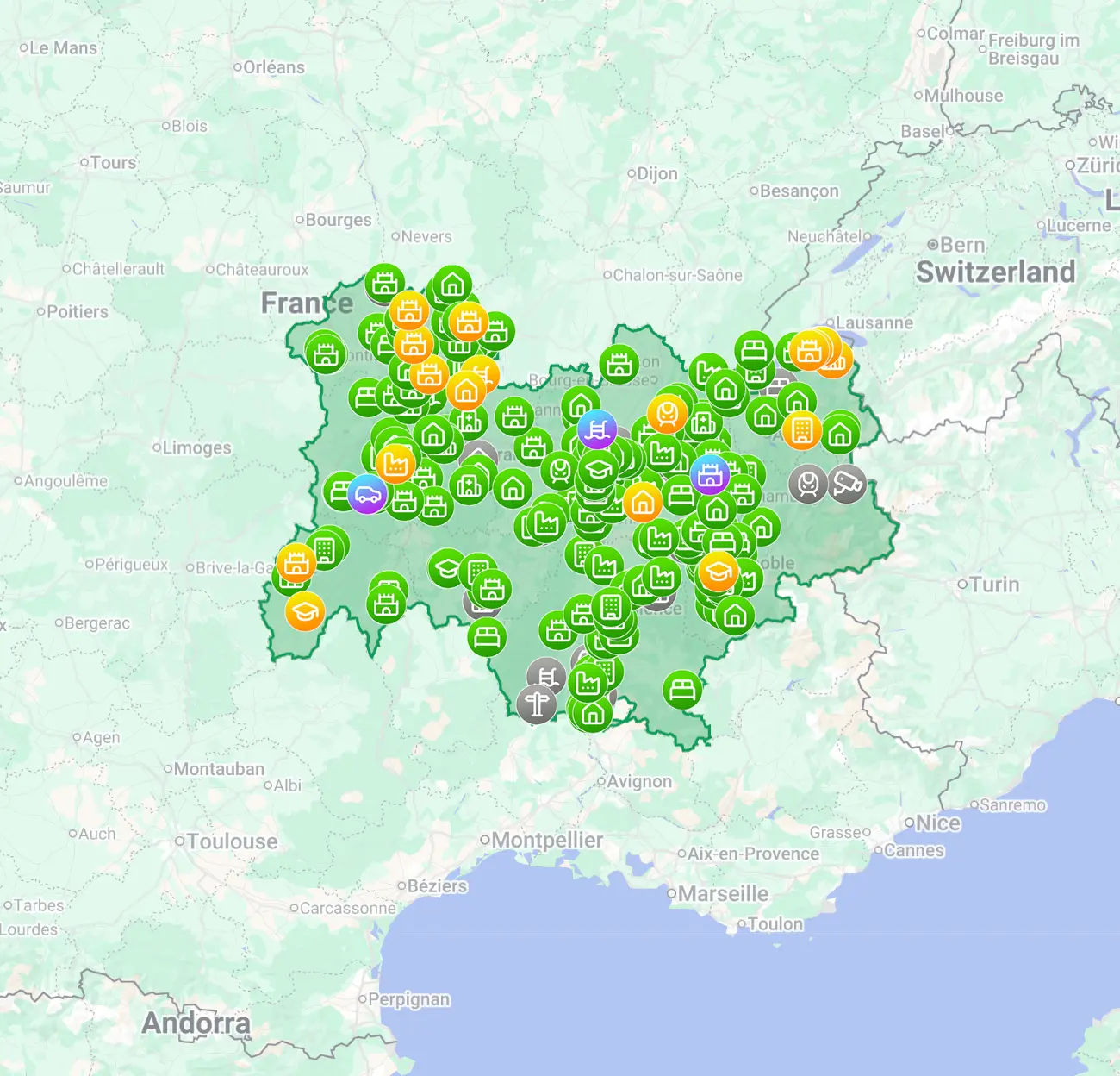
What is the Auvergne-Rhône-Alpes urbex map?
The Auvergne-Rhône-Alpes urbex map is a curated regional map designed to help users find verified urbex locations in Auvergne-Rhône-Alpes more efficiently. Instead of relying on scattered social posts or outdated lists, it organizes abandoned places into a practical regional reference that supports trip planning, comparison of areas, and responsible exploration.
Quick summary
- The map focuses on verified urbex locations in Auvergne-Rhône-Alpes.
- It is built for efficient planning across a large and diverse region.
- It helps users identify abandoned places in Auvergne-Rhône-Alpes without relying on random online pins.
- It follows a preservation-first approach and does not encourage trespassing or forced entry.
- It is useful for both first-time visitors and experienced explorers building regional routes.
- It complements broader resources such as Browse all urbex maps and the regional page for Urbex locations in Auvergne-Rhône-Alpes.
Quick facts
| Aspect | Details |
|---|---|
| Region covered | Auvergne-Rhône-Alpes |
| Main use | Finding and comparing urbex spots in Auvergne-Rhône-Alpes |
| Content focus | Curated abandoned places, regional discovery, route planning |
| MapUrbex approach | Verified locations and preservation-first selection |
| Best for | Beginners, photographers, and experienced explorers planning multi-stop trips |
| Safety reminder | Always respect property rights, local law, and changing on-site conditions |
Why use a curated map for urbex spots in Auvergne-Rhône-Alpes?
A curated map is useful because Auvergne-Rhône-Alpes is large, geographically varied, and full of uneven online information. Good planning matters more in a region where distances are long, road access changes by area, and many abandoned places sit in sensitive or private environments.
The main advantage is efficiency. Instead of checking isolated forum threads, duplicate map pins, or vague social captions, you start with a structured regional view. That makes it easier to compare the Lyon area, former industrial corridors, mountain-edge towns, and smaller rural zones.
A second advantage is quality control. Verified locations do not mean permanent access, but they do reduce noise. In practice, that means fewer irrelevant pins, fewer misleading references, and a better starting point for research.
If you want to compare regions first, Browse all urbex maps gives the broad overview. If your focus is local, the dedicated page for Urbex locations in Auvergne-Rhône-Alpes is the most direct entry point.
What kinds of abandoned places can you find in Auvergne-Rhône-Alpes?
Auvergne-Rhône-Alpes offers a broad mix of abandoned places, especially industrial sites, former hospitality buildings, medical structures, transport-related remnants, and rural heritage properties. The region is interesting because the distribution is not limited to one urban core.
In practical terms, explorers often look for:
- disused factories and workshops
- abandoned hotels and guest houses
- hospitals, clinics, or care facilities
- castles, manor houses, and old villas
- schools, farms, and isolated rural buildings
- smaller infrastructure sites linked to transport or local industry
This variety is one reason the carte des lieux abandonnés Auvergne-Rhône-Alpes is a frequent search intent. Users are not only looking for a single site. They want a map that helps them sort locations by type, area, and trip logic.
For inspiration, the related article Auvergne-Rhône-Alpes Urbex Map: 12 Unusual Places Around Lyon and Clermont-Ferrand shows the range of sites people associate with the region. The broader overview 15 Fascinating Abandoned Places in Auvergne-Rhône-Alpes: Castles, Factories, Hospitals and Hotels is also useful for understanding the diversity of locations.
How does MapUrbex verify urbex locations in Auvergne-Rhône-Alpes?
MapUrbex verifies locations by focusing on curation quality, regional relevance, and practical usefulness rather than quantity alone. The goal is not to flood the map with unfiltered pins. The goal is to provide a more reliable working map for people researching spots urbex Auvergne-Rhône-Alpes.
In a regional guide, verification usually matters in four ways:
- The location should correspond to a real abandoned or disused site.
- The entry should be relevant enough to help trip planning.
- Duplicate or low-value pins should be limited.
- The map should remain usable as conditions change over time.
A verified map is still not a legal guarantee. Access status, ownership, security, and structural stability can change quickly. That is why responsible urbex always requires an additional check before any visit.
How should you prepare a visit responsibly?
Responsible preparation means treating every location as uncertain until you confirm legality, safety, and current conditions. A good map improves research, but it never replaces judgment on the ground.
Use this checklist before planning a stop:
- confirm whether the site is on private or restricted land
- never force entry, climb barriers, or bypass locks
- avoid visiting alone in unstable or remote environments
- wear appropriate footwear and basic protective gear
- monitor weather, light, terrain, and road access
- leave no trace and do not move or remove objects
Legal and safety reminder: MapUrbex is built for responsible exploration. Do not trespass, vandalize, steal, or publish information in ways that increase damage to fragile sites.
For many users, the biggest value of a curated map is not thrill-seeking. It is better decision-making: fewer wasted detours, clearer regional comparisons, and more respectful behavior around abandoned heritage.
Where should beginners start if they want a free version first?
Beginners should start with a free overview first, then move to a regional map once they know the type of places and travel radius they want. This approach keeps the research process simple and reduces low-quality planning.
Two useful starting points are Access the free urbex map and the guide Free Urbex Map: Download the Updated PDF and Google Maps Version. After that, users who specifically want lieux abandonnés Auvergne-Rhône-Alpes can move to the dedicated regional resource.
FAQ
Is the Auvergne-Rhône-Alpes urbex map useful for beginners?
Yes. A regional map is often easier for beginners than scattered social media posts because it gives a structured overview. It helps new users compare distances, types of sites, and realistic day-trip options.
Does a verified map mean every site is legally accessible?
No. Verification does not mean automatic legal access. Ownership, restrictions, and security conditions can change, so every site still requires a legality and safety check before any visit.
What makes Auvergne-Rhône-Alpes a strong region for urbex?
The region combines major urban areas, industrial history, tourism infrastructure, mountain settlements, and rural heritage. That mix creates a wide range of abandoned places across different landscapes.
Is a regional map better than searching random pins online?
In most cases, yes. A regional map is better for route planning because it reduces duplicate information, gives geographic context, and helps you compare clusters of sites instead of chasing isolated mentions.
Can the map replace on-site judgment?
No. A map is a planning tool, not a guarantee. Structural danger, access restrictions, and local sensitivity always need to be assessed independently.
Conclusion
A strong Auvergne-Rhône-Alpes urbex map does more than show points on a screen. It helps users research abandoned places in Auvergne-Rhône-Alpes with more structure, less noise, and a more responsible mindset.
That is the core value of MapUrbex: verified locations, regional curation, and preservation-first exploration. If you want to save time and plan more intelligently, start with the free resource and then move to the dedicated regional map.
Start with the free map
Access the free urbex map
