A practical guide to the Michigan urbex map, including the best urbex spots in Michigan, major regional patterns, and how to research Great Lakes sites responsibly.
Michigan Urbex Map: Best Urbex Spots Around the Great Lakes
Michigan is one of the most varied urbex states in the US. Its abandoned places come from several overlapping histories: auto manufacturing, mining, shipping, tourism, and long-term population change.
That mix matters. A Michigan urbex map is not limited to Detroit. It also includes factory corridors around Flint and Saginaw, mining landscapes in the Upper Peninsula, and shoreline properties tied to Great Lakes transport and resort economies.
MapUrbex focuses on verified locations, responsible urbex, and preservation-first research. Always check ownership, local rules, and structural conditions. Never force entry, trespass, or take unnecessary risks.
Where are the best urbex spots on a Michigan urbex map?
The best urbex spots in Michigan usually cluster in Detroit's former industrial districts, the factory belts around Flint and Saginaw, the mining landscapes of the Upper Peninsula, and aging shoreline properties linked to Great Lakes transport and tourism. A strong map of abandoned places in Michigan helps you compare region, site type, and access context instead of relying on random social posts.
Quick summary
- Michigan has one of the broadest mixes of industrial, mining, civic, and shoreline abandonment in the Midwest.
- Detroit remains the state's best-known urbex zone, but it is not the only one worth mapping.
- Flint, Saginaw, Bay City, and the Upper Peninsula are essential for understanding Michigan's abandoned landscape.
- Great Lakes urbex spots often face faster weather damage because of moisture, freeze-thaw cycles, and exposure.
- A good Michigan urbex map is useful for research, filtering, and context, not just for collecting pins.
- Responsible exploration starts with legal checks, site history, and preservation-minded behavior.
Quick facts
- State: Michigan
- Geo scope: Statewide
- Main site types: Factories, schools, churches, theaters, hospitals, mines, maritime infrastructure, motels, resorts
- Best-known urbex zones: Detroit, Flint, Saginaw, Bay City, Upper Peninsula mining districts, shoreline resort corridors
- Historic drivers: Auto industry decline, industrial restructuring, mining contraction, disinvestment, population shifts, seasonal tourism change
- Great Lakes context: Ports, ship-related infrastructure, resort properties, and weather-exposed buildings
- Best use of a map: Comparing clusters, ownership context, and research value before any visit planning
- Safety note: Michigan sites often have water damage, unstable floors, missing stairs, vandalism, and harsh winter conditions
Why does Michigan have so many abandoned places?
Michigan has so many abandoned places because several industries expanded quickly and then contracted over many decades. Auto manufacturing, mining, shipping, rail infrastructure, and seasonal tourism all left large building stocks behind when jobs, ownership, or population moved elsewhere.
Detroit is the clearest example, but the pattern is statewide. When a major employer closed, nearby schools, storefronts, churches, and housing often declined as well. That is why a Michigan urbex map often shows clusters rather than isolated ruins.
The Great Lakes setting also changes how abandonment looks. Moisture, cold winters, freeze-thaw damage, and long vacancy periods accelerate deterioration. Some buildings that survived for decades in dry regions fail much faster near water or after repeated winter exposure.
If you are comparing regions beyond this state, Browse all urbex maps to see how Michigan fits into broader US abandonment patterns.
Which regions should you prioritize on a Michigan urbex map?
The best regions depend on the kind of site you want to study. Detroit is strongest for density and scale, Flint and Saginaw for industrial legacy, the Upper Peninsula for mining history, and shoreline zones for hotels, marinas, and transport infrastructure.
A statewide map is useful because Michigan's urbex geography is not uniform. Some areas offer dense urban ruins. Others are better for isolated industrial remnants, extractive sites, or decaying seasonal properties.
| Region | Typical site types | Why it matters | Research note |
|---|---|---|---|
| Detroit metro | Factories, schools, churches, theaters, commercial blocks | Highest concentration and strongest urbex identity | Many famous ruins are now demolished, secured, or under redevelopment |
| Flint | Industrial sites, civic buildings, neighborhood vacancies | Direct link to auto industry contraction | Conditions vary sharply block by block |
| Saginaw and Bay City | Warehouses, riverfront industry, mills, civic structures | Strong industrial and transport history | Water exposure and partial reuse are common |
| Upper Peninsula | Mining remains, company-town structures, rail remnants | Distinct landscape shaped by extraction | Remote conditions require extra preparation |
| Great Lakes shoreline belts | Motels, resorts, marinas, transport-related buildings | Shows tourism and maritime decline | Seasonal visibility changes site condition and access context |
What are the best urbex areas in Michigan?
The best urbex areas in Michigan are the places where history, building density, and regional pattern overlap. The five zones below are the most useful starting points for understanding the state's abandoned landscape.
1. Detroit's industrial belt and neighborhood commercial strips
Detroit remains the symbolic center of Michigan urbex because it combines scale, history, and visual variety. Former auto-related buildings, warehouses, schools, churches, apartment blocks, and neighborhood retail corridors can all appear within a relatively compact area.
Historically famous ruins such as the Packard plant helped define Detroit's global urbex reputation, even though many headline sites have since been demolished, fenced, or pushed into redevelopment. That is an important reminder: a Michigan urbex map should reflect current verification, not old internet mythology.
Detroit is also the best example of why context matters more than hype. Some buildings are highly visible but unusable for responsible exploration because of legal restrictions, active work, or severe structural damage. Others are less famous but more relevant for architectural or industrial history research.
2. Flint's factory legacy and surrounding civic vacancies
Flint is one of the most important areas for anyone studying abandoned places in Michigan because its landscape is closely tied to the rise and contraction of General Motors. The result is a mix of industrial remnants, vacant institutional buildings, and weakened neighborhood commercial corridors.
The city's abandonment pattern is less about one iconic ruin and more about an entire urban system shaped by factory loss. That makes Flint especially useful on a map of abandoned places in Michigan: it shows how industrial decline spreads into schools, shops, municipal buildings, and housing.
Researchers also value Flint because it helps explain Michigan beyond Detroit. If Detroit represents scale, Flint represents the social and spatial aftereffects of dependence on a single dominant industry.
3. Saginaw and Bay City's riverfront industry
Saginaw and Bay City deserve more attention than they usually get in statewide lists. These cities combine riverfront industry, warehousing, rail-linked spaces, and older civic properties that reflect the manufacturing and transport systems of eastern Michigan.
Their urbex value comes from variety. You may see former industrial corridors, vacant commercial architecture, and maritime-related infrastructure within the same regional network. For Great Lakes urbex spots, this inland-waterway context is especially important.
These areas also show how abandonment can remain partially hidden. A site may sit beside active property, reused blocks, or functioning roads while still belonging to a wider pattern of disinvestment. That makes careful research more important than visual assumptions.
4. Upper Peninsula mining settlements and extraction landscapes
The Upper Peninsula offers a very different version of Michigan urbex. Instead of dense postindustrial city blocks, you find mining remains, company-town structures, rail traces, and isolated buildings shaped by copper and iron extraction.
This is one of the best zones for people interested in historical landscape rather than only architecture. The relationship between mines, worker housing, transport corridors, and remote settlement patterns is often more legible here than in large cities.
The tradeoff is distance and exposure. Remote roads, severe weather, and uneven cellular coverage can turn simple research into a logistical problem. Preservation-first planning matters more in the Upper Peninsula because damage, isolation, and rescue delays can all be serious factors.
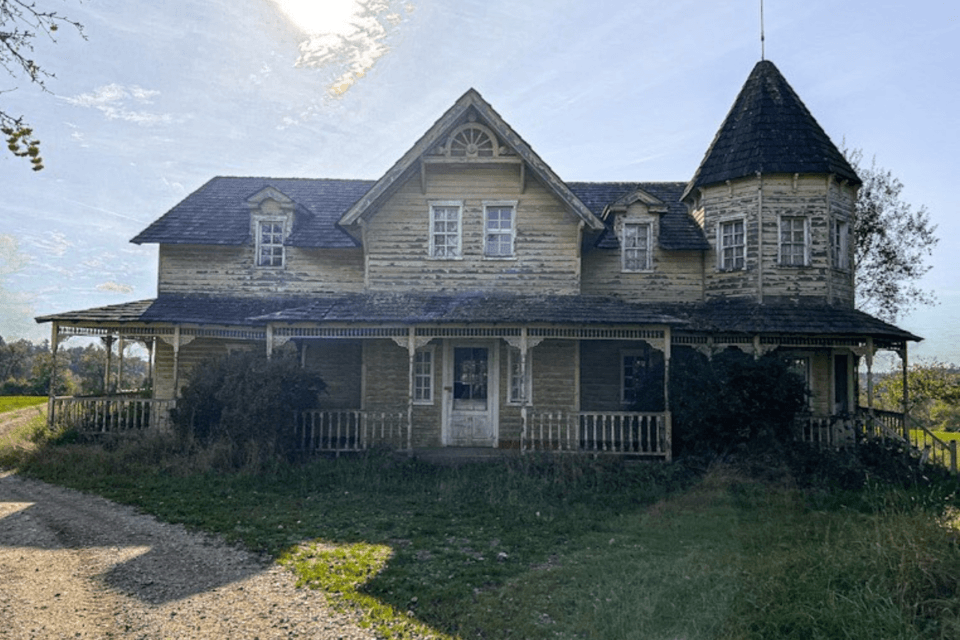
5. Great Lakes shoreline resorts, marinas, and transport infrastructure
Some of the most overlooked best urbex spots in Michigan are tied to the shoreline economy. Along lake corridors and older travel routes, you can find abandoned motels, seasonal resorts, marinas, service buildings, and transport-related properties that declined as travel patterns changed.
These sites often look different from classic factory ruins. They tell stories about tourism, recreation, shipping, and small-town commercial change. That makes them valuable additions to a Michigan urbex map, especially for anyone researching Great Lakes regional identity.
They also deteriorate quickly. Wind, salt exposure in some contexts, humidity, ice, and repeated water intrusion can erase interiors and weaken structures faster than expected. A shoreline ruin that looked accessible in an old photo may now be unsafe or gone.
How should you research Michigan abandoned places responsibly?
You should research Michigan abandoned places by combining map data, ownership checks, historic context, and recent condition verification. The goal is not to chase the most secret pin. The goal is to understand whether a site is legal to access, still standing, and safe enough to evaluate from a preservation-first perspective.
Start with a method instead of a rumor. Use Tools to Find Abandoned Places: Best Urbex Research Tools and Maps to build a repeatable research workflow. Then read How to Find Secret Urbex Places: Real Methods Explained if you want to understand how experienced researchers verify a place without depending on viral coordinates.
If you are new to the subject, How to Start Urbex: A Beginner's Guide to Urban Exploration is the best place to begin. It covers mindset, basic preparation, and the difference between curiosity and careless behavior.
A few rules matter in Michigan more than most people expect:
- Do not assume an old location is still abandoned.
- Do not enter active industrial or port property.
- Do not rely on winter conditions to bypass barriers or hazards.
- Do not share sensitive access details publicly.
- Leave sites exactly as you found them.
Access the free urbex map
What makes Great Lakes urbex spots different from other US regions?
Great Lakes urbex spots are different because water, cold, and industrial history combine in a very specific way. Buildings often decay through humidity, corrosion, freeze-thaw stress, and long seasonal exposure, while the surrounding landscape reflects shipping, manufacturing, and resort economies rather than only inland decline.
This affects both appearance and survival. Interiors can collapse faster, metal can deteriorate heavily, and shoreline structures may change dramatically after only a few winters. In practical terms, older photos are less reliable in Michigan than in some drier regions.
The Great Lakes setting also broadens what counts as an abandoned site. In Michigan, urbex research often includes breakwaters, docks, depots, marinas, old hotels, roadside resorts, and worker settlements linked to water-based trade. That variety is one reason the state remains so important for serious mapping.
FAQ
Is Detroit still the main area on a Michigan urbex map?
Yes, Detroit is still the main reference point because it has the highest density of well-known industrial and institutional abandonment. However, it no longer tells the whole story. Many famous Detroit ruins have been demolished, redeveloped, or secured, so statewide research is more useful than a Detroit-only approach.
Are Great Lakes shoreline sites easier to access than city ruins?
No, shoreline sites are not automatically easier to access. Many are on private land, near active infrastructure, or in worse structural condition than they appear from the outside. Exposure to water and weather can make them especially unstable.
What is the best season for researching abandoned places in Michigan?
Late spring through early fall is usually the most practical season for field research. Winter adds snow, ice, early darkness, and hidden hazards. Seasonal foliage can reduce visibility in summer, but it is generally safer than relying on frozen conditions.
Can a public map replace on-the-ground verification?
No, a public map cannot replace current verification. Ownership, demolition, redevelopment, and structural collapse can change a site quickly. A good map is a research tool, not a guarantee of safe or legal access.
Should beginners start with large industrial ruins in Michigan?
Usually not. Large industrial ruins are often the most complex and dangerous sites in the state. Beginners are better served by learning research methods, legal awareness, and risk assessment before considering any advanced location type.
Conclusion
A Michigan urbex map is valuable because it reveals patterns, not just places. The state's abandoned landscape stretches from Detroit industry to Upper Peninsula extraction and from riverfront warehouses to Great Lakes resort decay.
The best approach is to research broadly, verify carefully, and explore responsibly. If you want to expand your planning beyond this guide, Browse all urbex maps and use MapUrbex as a preservation-first reference.
Access the free urbex map