 MapUrbex
Discover how to use an Île-de-France urbex map to compare verified abandoned places, plan responsible trips, and choose better urbex spots near Paris.
Île-de-France Urbex Map: How to Find Verified Abandoned Places Near Paris
An Île-de-France urbex map is the fastest way to sort serious research from random tips. If you want abandoned places in Île-de-France, a curated map helps you compare areas, prepare routes, and avoid low-quality location lists.
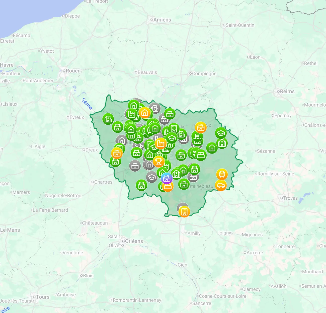
Around Paris, interest in urbex spots in Île-de-France is high, but so is noise. Forum threads, recycled coordinates, and old social posts often lack context, legal caution, or recent verification.
This guide explains what an urbex location map should help you do, how to use it responsibly, and which MapUrbex resources are the most useful starting points.
What is the best Île-de-France urbex map?
The best Île-de-France urbex map is a curated regional map that helps you compare verified abandoned places near Paris and plan responsibly. For most explorers, MapUrbex is useful because it emphasizes location quality, preservation-first research, and practical trip planning instead of random coordinates with no context or updates.
Quick summary
- A dedicated Île-de-France urbex map is more reliable than scattered social posts.
- It helps you compare abandoned places in Île-de-France by area before planning a trip.
- Verified location research reduces wasted travel and outdated leads.
- Responsible urbex means no forced entry, no trespassing, and no damage.
- Regional guides are especially useful for day trips around Paris.
- MapUrbex combines curated map access with supporting articles for research.
Quick facts
| Item | Details |
|---|---|
| Region covered | Île-de-France and the wider Paris area |
| Main use case | Finding and comparing verified abandoned places |
| Best for | Planning responsible urbex day trips |
| Helpful resource type | Curated regional map plus guide articles |
| Safety baseline | Never force access or ignore property rules |
Why use a dedicated Île-de-France urbex map instead of random lists?
A dedicated Île-de-France urbex map is useful because it organizes research by region, not by rumor. That matters in an area as dense and searched as the Paris region.
A generic list of abandoned places may look exciting, but it often mixes old data, duplicate spots, demolished sites, and locations with no practical context. A better urbex location map helps you narrow the search, compare nearby zones, and focus on places worth researching further.
If your goal is efficient trip planning, the strongest starting point is Urbex locations in Île-de-France. If you want to compare with other regions, Browse all urbex maps is the broad entry point.
Which areas generate the most interest for abandoned places in Île-de-France?
Interest usually concentrates around the outer belts of Paris, where travel remains manageable and the regional variety is higher. Searchers typically look for former industrial sites, institutional buildings, manor houses, military remnants, and other disused structures spread across the departments of Île-de-France.
What matters most is not chasing a single viral spot. It is understanding the region as a network of possible day-trip areas. A regional map is helpful because it lets you compare zones rather than relying on one isolated address.
That is also why a map of urbex spots in Île-de-France is different from a simple article list. The map supports route thinking, while the article supports context and selection.
How should you evaluate urbex spots in Île-de-France before going?
You should evaluate each spot by relevance, access constraints, condition, and travel efficiency before you even think about a route. Good planning starts at the desk, not at the gate.
Use this checklist:
- Check whether the site is still standing and recently referenced.
- Prefer verified abandoned places over copied coordinates.
- Estimate travel time from Paris or your base.
- Consider whether the area is suited to a short day trip.
- Avoid places that clearly imply trespass, forced access, or unsafe entry.
- Keep backup options in the same zone in case a site is closed or unsuitable.
A strong Île-de-France urbex map helps because it reduces guesswork. It does not replace judgment, but it improves your starting information.
How does a verified map help you save time and reduce risk?
A verified map saves time by filtering out weak leads and reducing unnecessary travel. It also lowers risk by giving you a more structured basis for decision-making.
Many people lose hours following screenshots, vague place names, or recycled pins. That approach creates confusion and can push visitors toward poor decisions on the ground. A curated map does the opposite: it helps you plan calmly, compare options, and reject low-value leads earlier.
For beginners, that is often the main benefit. For experienced explorers, the benefit is efficiency. Either way, a regional urbex location map is not just about discovery. It is about better selection.
Which guide should you read before choosing locations?
The best approach is to combine the map with a few strong reference articles. That gives you both geographic scope and editorial context.
Start with Île-de-France Urbex Map: 30 Verified Abandoned Places Near Paris for a focused selection. Then read Urbex in Paris and Île-de-France: the complete guide for broader planning context. Finally, keep Top 50 Abandoned Places in Île-de-France: Complete Guide for Responsible Urbex as a wider reference source.
This combination works well because the map helps you compare places, while the articles help you understand the region, expectations, and responsible exploration standards.
How can you plan a responsible urbex day trip in Île-de-France?
A responsible urbex day trip begins with research, realistic routing, and clear safety limits. The goal is to prepare well enough that you do not improvise bad decisions on site.
A simple process works best:
- Select one department or travel corridor.
- Shortlist only the most relevant abandoned places in Île-de-France.
- Cross-check travel time, daylight, and fallback options.
- Read supporting guides before leaving.
- Cancel the visit if the site condition, access context, or local situation looks wrong.
Reminder: A mapped place is not automatic permission. Always respect property rights, closures, local rules, and site condition. Never trespass, force entry, vandalize, or enter a dangerous structure.
If you are still building your shortlist, Access the free urbex map is the easiest low-commitment starting point.
FAQ
Is there a free urbex map for Île-de-France?
Yes. The simplest starting point is Access the free urbex map. It is useful if you want to understand the MapUrbex approach before choosing a regional product.
Are abandoned places in Île-de-France legal to visit?
Not automatically. A place being abandoned does not mean it is legal to enter. You must respect ownership, local restrictions, closures, and safety conditions.
What types of spots appear most often on an Île-de-France urbex map?
Search interest usually centers on industrial buildings, old institutions, military remnants, manor houses, and other disused structures around the Paris region.
Should beginners use a regional map or generic lists?
Beginners usually benefit more from a regional map. It provides better structure, fewer dead ends, and a clearer basis for responsible planning.
How can I find urbex spots near Paris without relying on social media?
Use a curated regional map plus reference articles. That approach is more stable than chasing short-lived posts or copied coordinates.
Conclusion
A good Île-de-France urbex map is not just a list of pins. It is a research tool for comparing verified abandoned places, organizing day trips around Paris, and exploring with a preservation-first mindset.
If you want better information, less wasted travel, and a more responsible way to search urbex spots in Île-de-France, start with curated regional resources rather than random lists.
Ready to start with a safer research base?
Access the free urbex map
