Explore a Brittany urbex map with 15 abandoned-place profiles worth spotting in Cotes-d'Armor and Finistere. A practical, safety-first guide for responsible research.
Brittany Urbex Map: 15 Mysterious Places to Spot in Cotes-d'Armor and Finistere
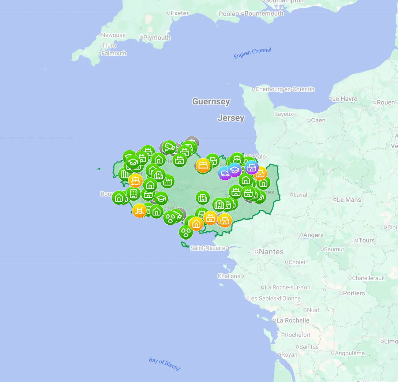
A good Brittany urbex map helps you sort abandoned places by type, condition, and legal context before you plan a trip. In a region as varied as Brittany, that matters more than chasing random coordinates.
This guide focuses on Cotes-d'Armor and Finistere while keeping the wider regional picture in view. It is designed for informational research, daylight scouting, and preservation-first exploration.
MapUrbex prioritizes verified locations, curated map layers, and responsible urbex. That means no forced entry, no trespassing advice, and no publication of risky access details.
Quick summary
- A Brittany urbex map is most useful when it filters places by department, site type, visibility, and safety notes.
- Cotes-d'Armor often stands out for manor houses, farms, chapels, and smaller rural complexes.
- Finistere is especially strong for coastal ruins, maritime infrastructure, weathered hotels, and military remnants.
- The best research method is to combine a curated map with satellite view, land status checks, and on-site caution.
- Responsible urbex in Brittany starts with legal boundaries, daylight visits, and strict respect for preservation.
- For broader context, see Urbex in Brittany: 5 Types of Abandoned Places Worth Knowing and Top 50 Abandoned Places in Brittany: Verified Urbex Guide.
What is a Brittany urbex map and how should you use it?
A Brittany urbex map is a curated regional reference that helps you identify abandoned-place profiles across Cotes-d'Armor, Finistere, Morbihan, and Ille-et-Vilaine. Its real value is not promising easy entry. Its value is helping you compare site types, visibility, condition, and safety constraints so you can plan a responsible visit.
If you want to compare regional coverage, you can Browse all urbex maps or start with Brittany Urbex Map: Hidden Abandoned Places Across Brittany.
Quick facts
| Topic | Key information |
|---|---|
| Region covered | Brittany: Cotes-d'Armor, Finistere, Morbihan, Ille-et-Vilaine |
| Main search intent | Informational research and trip planning |
| Best-known departments for this topic | Cotes-d'Armor and Finistere |
| Common place types | Manors, farms, schools, hotels, bunkers, warehouses, chapels |
| Best scouting style | Daylight exterior survey and legal access checks |
| Main risks | Coastal weather, unstable floors, private property, hidden shafts |
| Best toolset | Verified map, satellite view, notes on visibility, backup route |
Which 15 place types should you look for on a Brittany urbex map?
The 15 most useful place profiles to track on a Brittany urbex map are the ones that reflect Brittany's rural, coastal, religious, and industrial history. In practice, that means looking for recurring categories rather than chasing one viral spot.
-
Abandoned manor houses These are among the most searched urbex spots in Brittany. They often appear in wooded estates or on the edge of small villages.
-
Rural farmsteads Brittany has many disused farms with collapsed barns, empty courtyards, and weathered stone outbuildings. They are common in both inland Cotes-d'Armor and western Finistere.
-
Coastal villas Near the sea, older villas can fall out of use after ownership disputes, erosion issues, or redevelopment delays. Exterior scouting is often the safest way to document them.
-
Small fishing or maritime buildings Finistere is especially rich in abandoned maritime structures. These may include storage sheds, harbor-side service buildings, or disused workshops.
-
Closed rural schools Population shifts have left some small educational buildings vacant. They are useful markers on a map of abandoned places in Brittany because they are easy to classify and verify from outside.
-
Disused chapels and rectories Religious architecture is part of Brittany's visual identity. Some smaller complexes become inactive and remain visible from nearby roads or public paths.
-
Empty seaside hotels Along parts of the coast, old hotels and guesthouses can remain in suspended redevelopment. These spots are visually striking but often exposed to rapid decay.
-
Sanatorium or clinic wings Former care facilities appear less often, but they are major interest points when verified. They require extra caution because interiors can be structurally weak.
-
Abandoned mills Watermills and agricultural mills fit well within a Brittany urbex map because they connect landscape history with industrial traces.
-
Forgotten greenhouses or nurseries These are less famous than manors, yet they can produce strong visual documentation. Glass, metal frames, and vegetation create fast-changing conditions.
-
Old railway buildings Small stations, waiting rooms, and trackside service structures are relevant for urbex Cotes-d'Armor and parts of inland Brittany. Many are identifiable without entering the site.
-
Agricultural workshops This category includes repair garages, feed depots, and machinery sheds. They may look ordinary, but they reveal local economic history clearly.
-
Industrial warehouses Warehouses are among the easiest abandoned-place categories to classify on a map. The challenge is not finding them. The challenge is confirming status and legal access conditions.
-
Military remnants visible from public approaches Brittany's coastline includes defensive remains and support buildings. These demand extra restraint because terrain, cliffs, and sealed sections can be dangerous.
-
Closed leisure venues Old campsites, dance halls, mini-golf sites, and seaside recreation buildings also belong on a spot urbex Brittany shortlist. They often tell a clear story of changing tourism patterns.
How do Cotes-d'Armor and Finistere differ for urbex research?
Cotes-d'Armor usually rewards rural and heritage-oriented research, while Finistere is stronger for coastal atmosphere, maritime ruins, and wind-beaten structures. Both departments are rich in abandoned places, but the visual character is different.
| Department | Often-seen place profiles | Typical visual mood | Main caution |
|---|---|---|---|
| Cotes-d'Armor | Manors, farmsteads, chapels, schools, mills | Stone architecture, woodland edges, inland villages | Private estates and hidden structural decay |
| Finistere | Coastal villas, maritime buildings, bunkers, hotels, workshops | Sea exposure, dramatic weather, corrosion, open horizons | Slippery terrain, cliff risk, fast weather shifts |
For many readers, the best route is to start with the department that matches the visuals you want. If you want a broader regional shortlist, the reference article remains Top 50 Abandoned Places in Brittany: Verified Urbex Guide.
How can you use a map of abandoned places in Brittany safely and legally?
You should use a map of abandoned places in Brittany as a research tool, not as a shortcut to illegal entry. Responsible urbex means checking ownership, respecting barriers, and leaving every place exactly as found.
A practical checklist:
- Prefer daylight scouting over night visits.
- Check whether the site can be observed legally from a public road or path.
- Never force locks, fences, shutters, or boarded windows.
- Assume floors, stairs, roofs, and basements are unstable.
- Avoid solo visits in remote coastal or rural sectors.
- Do not publish exact coordinates of fragile locations.
- If a place is active, monitored, or clearly private, leave immediately.
MapUrbex is built around that logic: verified locations, context notes, and preservation-first filtering.
When are weather and season especially important in Brittany?
Weather and season are especially important in Brittany because rain, wind, salt exposure, and vegetation can change a site's condition very quickly. A place that looks accessible on a map can become unsafe after a storm or during peak overgrowth.
In practical terms:
- Winter improves visibility through leafless vegetation, but surfaces are wetter and colder.
- Spring is useful for balanced daylight and moderate growth.
- Summer offers long days, but tourism and vegetation can reduce discretion and visibility.
- Autumn is photogenic, yet wind and rain increase risk around roofs, coastlines, and glass.
For first-time planning, compare weather windows before any trip and keep backup sites in the same area.
What makes a verified urbex map better than a random list of spots?
A verified urbex map is better because it reduces noise. Random lists often recycle outdated, demolished, converted, or inaccessible sites. A curated map does the opposite: it helps you sort what is still relevant.
That matters in Brittany because the region changes quickly. Coastal redevelopment, rural demolition, vegetation growth, and security upgrades can make an old list useless. A curated map helps you focus on places that still matter for research.
FAQ
Is urbex legal in Brittany?
Urbex itself is not a special legal status. What matters is where you go and how you behave. Trespassing, forced access, and property damage are illegal, so responsible exploration should stay within legal boundaries.
Which department is best for coastal ruins in Brittany?
Finistere is usually the strongest choice for coastal ruins, maritime infrastructure, and exposed military remnants. Cotes-d'Armor can also deliver strong coastal sites, but Finistere is generally more associated with that atmosphere.
Can a free map replace a verified map?
A free map can be useful for discovery, but a verified map is better for filtering outdated or misleading entries. The more fragile or remote the site, the more valuable curation becomes.
Should exact coordinates of abandoned places be shared publicly?
In most cases, no. Publicly spreading exact coordinates can accelerate vandalism, theft, and unsafe visits. Preservation-first practice favors selective sharing and contextual guidance.
What should you bring for a daylight scouting trip in Brittany?
Bring weatherproof clothing, charged phone navigation, a backup battery, water, sturdy footwear, and a basic first-aid kit. Do not treat photography gear as a substitute for safety planning.
Conclusion
A Brittany urbex map is most useful when it helps you identify patterns: manor houses in Cotes-d'Armor, maritime ruins in Finistere, and many hybrid site types across the region. The goal is not to collect reckless coordinates. The goal is to research better, move more carefully, and preserve what remains.
If you want to continue, Browse all urbex maps for wider coverage or test the curated entry point below.
Access the free urbex map