Use a curated USA urbex map to find abandoned places near you, compare regions, and research locations with a responsible, verification-first approach.
USA Urbex Map: Find Abandoned Places Near You Easily
A USA urbex map is one of the fastest ways to research abandoned places in a country this large. Instead of relying on scattered forum threads, vague social posts, or outdated pins, you can work from a curated view of locations by state, region, and site type.
MapUrbex is built for people who want better information and a more responsible workflow. The goal is not reckless access. The goal is to help you find abandoned places near you, understand what kind of site you are looking at, and plan research with preservation, legality, and safety in mind.
Where can you find abandoned places near you in the United States?
The easiest way to find abandoned places near you in the United States is to use a curated USA urbex map that groups locations by state, city, and site type. A structured map is faster than random search results, and it gives you a better starting point for responsible research, public-viewpoint scouting, and permission-based visits.
Quick summary
- A USA urbex map helps you search abandoned places by region, state, and category.
- Curated map data is usually more useful than scattered posts because it is easier to verify and compare.
- The most common U.S. site types include factories, hospitals, schools, amusement parks, and hotels.
- Responsible urbex starts with legality, permission, structural awareness, and a leave-no-trace mindset.
- MapUrbex focuses on verified locations, preservation-first guidance, and practical search tools.
- If you want broad coverage, start with the free map and then move to the United States product page.
Quick facts
- Country covered: United States
- Primary use: Researching abandoned places near you
- Best for: State-by-state discovery and trip planning
- Common location types: Industrial sites, medical buildings, schools, resorts, theme parks
- Recommended approach: Verification first, access only when legal, no forced entry
- Related hub: Browse all urbex maps
Why use a USA urbex map instead of random search results?
A USA urbex map is more useful than random search results because it organizes locations in a way that can actually be reviewed and compared. Search engines often surface copied lists, dead forum threads, generic map pins, or places that were demolished years ago.
This matters even more in the United States because distance changes the value of bad information. A location that looks close on a screen can still mean hours of driving. A structured map helps narrow the search before you spend time on route planning, satellite checks, ownership research, or permit questions.
It also gives you a better overview of density. Some states are rich in industrial ruins. Others are better known for mining remnants, military infrastructure, or roadside hospitality sites. When you can browse a dedicated map instead of isolated links, patterns become visible.
If you want to compare broader coverage first, start with Browse all urbex maps. It is the quickest way to understand how MapUrbex organizes countries and regions.
How does MapUrbex help you find abandoned places near you?
MapUrbex helps you find abandoned places near you by turning scattered information into a curated search system. Instead of guessing which posts are current, you can review locations within a map framework designed around verification, clarity, and responsible exploration.
| Feature | Why it helps |
|---|---|
| Curated country coverage | You can search the United States as a single territory instead of piecing together dozens of local sources. |
| State and regional logic | You can focus on realistic driving zones and plan research in a more efficient way. |
| Site-type variety | You can quickly spot whether an area trends industrial, medical, educational, or leisure-based. |
| Preservation-first positioning | The platform is designed for responsible urbex, not for encouraging illegal entry or damage. |
MapUrbex is especially useful if you want to find abandoned places near you without depending on vague coordinates passed around on social media. The platform is built around curated maps, practical discovery, and a cleaner research process.
For a starting point, use the free entry point below.
Access the free urbex map
If you already know that the United States is your target area, the country bundle is the more direct next step: Explore abandoned places in United States.
What kinds of abandoned places appear most often on a USA urbex map?
The most common places on a USA urbex map are large industrial properties, closed institutions, empty schools, abandoned leisure sites, and former hospitality buildings. These categories repeat across many states because they reflect long-term economic shifts, suburban decline, tourism change, and regional deindustrialization.
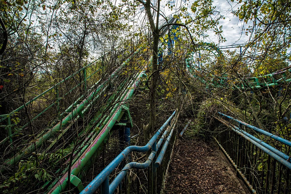
1. Abandoned amusement parks
Abandoned amusement parks are among the most visually recognizable U.S. urbex sites. They often combine large footprints, distinctive rides, decaying signage, and open-air structures that remain visible long after closure.
They are also some of the easiest sites to identify from historical imagery, news archives, and public-road vantage points. The abandoned Six Flags setting shown above reflects why these places attract so much attention, but they also require caution because fenced perimeters, unstable platforms, and strict ownership controls are common.
2. Closed hospitals and sanatoriums
Closed hospitals appear often on American abandoned-place maps because many healthcare campuses were consolidated, relocated, or partly decommissioned. These sites tend to have large buildings, clear institutional layouts, and strong local histories.
They also raise serious legal and ethical issues. Medical sites may contain hazards, active redevelopment zones, or protected records concerns. For that reason, they are best approached as research subjects first, not impulsive targets.
3. Industrial mills, factories, and power sites
Factories, mills, warehouses, and power-related structures form one of the largest categories in U.S. urbex. They are especially common in former manufacturing corridors, rail-linked towns, and rust belt regions.
These places are historically important because they document labor, transport, and regional industry. They are also high-risk environments. Structural failure, floor openings, chemicals, and private security are common issues, so map-based research is far safer than relying on rumor.
4. Schools, colleges, and civic buildings
Abandoned schools and public buildings are common because population change leaves entire educational and municipal properties underused or replaced. They are usually easier to understand spatially because classroom wings, gymnasiums, and auditoriums follow recognizable patterns.
From a research perspective, these sites are useful because local archives often preserve closure dates, district decisions, and redevelopment plans. That makes them better documented than many informal “hidden gem” locations promoted online.
5. Hotels, resorts, and roadside Americana
Hotels, motels, resorts, diners, and roadside service properties are widespread across the United States. They tell a clear story about changing highways, vacation habits, and regional tourism decline.
They also vary widely by region. Desert states may have stranded roadside businesses, while mountain and lake areas may show seasonal resort decline. On a good USA urbex map, these locations are easier to compare by travel corridor and historical context.
How should you search a USA urbex map by region?
The best way to search a USA urbex map is to start with realistic travel regions before narrowing to exact locations. The United States is too large for a flat nationwide search to be efficient unless you already know your destination.
A practical regional approach usually looks like this:
- Northeast: dense mill towns, hospitals, schools, and older urban infrastructure.
- Midwest: major industrial ruins, grain and rail sites, manufacturing plants, and depopulated civic buildings.
- South: abandoned resorts, flood-affected sites, closed hospitals, and scattered rural properties.
- West: mining remnants, military-linked infrastructure, desert roadside sites, and tourism-related closures.
This approach saves time because site patterns are not evenly distributed. If your goal is to find abandoned places near you, start with your surrounding states, then filter by the type of place you actually want to research.
For broader discovery across regions, Browse all urbex maps is the best starting hub.
What should you verify before visiting an abandoned place in the USA?
Before visiting an abandoned place in the USA, you should verify legality, ownership, current condition, and basic physical risk. Abandonment does not mean public access, and many locations are still monitored, under redevelopment, or clearly restricted.
Use this checklist before any in-person planning:
- Check ownership and access status. Private property rules still apply.
- Look for current activity. Some sites appear empty but are used for storage, redevelopment, or demolition staging.
- Review recent imagery and local news. Closures, fires, and demolition can change a site quickly.
- Avoid forced entry. Responsible urbex never depends on breaking locks, fences, or barriers.
- Assess environmental risk. Mold, unstable floors, exposed shafts, and chemicals are common.
- Protect the location. Do not vandalize, steal, publish damaging details, or disturb remaining artifacts.
MapUrbex is aligned with a preservation-first approach. That means research quality matters as much as location quantity. A useful map is not just a list of places. It is a better decision-making tool.
Which MapUrbex pages should you consult next?
The best next MapUrbex page depends on whether you want broad browsing, a free starting point, or the dedicated United States product. For most readers, the correct order is free map first, country product second, and related articles third.
Here are the most relevant next steps:
- Access the free urbex map
- Explore abandoned places in United States
- Browse all urbex maps
- Urbex Map USA 2026 (Flash Sale)
- Top 10 Abandoned Places to Explore in the USA in 2025
- Top 10 Abandoned Places in the USA to Explore in 2025
If your intent is transactional and you already know you want U.S. coverage, use the country page below.
Explore abandoned places in United States
FAQ
Is a USA urbex map better than Google Maps for abandoned places?
Yes, for this use case a curated USA urbex map is usually more practical than Google Maps alone. Google Maps is useful for roads, satellite view, and nearby services, but it is not built to catalog abandoned places accurately. A dedicated map gives you a stronger research layer before you use general mapping tools.
Can you legally visit abandoned places in the United States?
Sometimes, but only when access is lawful. Many abandoned places are still private property, active redevelopment sites, or fenced areas with explicit restrictions. Always verify status first and never assume that empty means permitted.
How do I find abandoned places near me without outdated information?
Start with a curated map, then cross-check local news, satellite imagery, and recent public records where possible. Outdated lists are common in urbex because demolition and redevelopment happen fast. A verification-first workflow reduces wasted trips and bad assumptions.
What types of abandoned places are most common in the United States?
Industrial sites are the most common broad category, followed by hospitals, schools, hotels, and leisure properties. The exact mix changes by region. Former manufacturing areas produce different patterns than tourism corridors or mining zones.
Is MapUrbex designed for responsible urbex?
Yes. MapUrbex emphasizes verified locations, curated maps, and preservation-first thinking. It is designed to support research and responsible decision-making, not trespassing, forced access, or destructive behavior.
Conclusion
A USA urbex map is the most efficient way to find abandoned places near you when you need structure, regional logic, and better verification. In a country as large and varied as the United States, organized research is not a luxury. It is the difference between useful planning and wasted time.
If you want a practical starting point, begin with the free map. Then move to the United States product when you need deeper coverage.
Access the free urbex map