A practical guide to planning an urbex road trip in Europe with curated maps, route logic, safety checks, and responsible exploration principles.
How to Plan an Urbex Road Trip in Europe
An urbex road trip in Europe works best when it is planned like a research project, not like a last-minute detour. Distances look short on a map, but access rules, road time, and site quality vary a lot from one region to another.
Europe is also one of the easiest continents for theme-based urban exploration travel. Former factories, hotels, transport sites, military remains, and leisure complexes can often be grouped into efficient regional loops.
The goal is not to chase random coordinates. The goal is to build a realistic abandoned places Europe trip with verified information, backup options, and a preservation-first mindset.
What is the best way to plan an urbex road trip in Europe?
The best way to plan an urbex road trip in Europe is to start with a curated urbex map, group verified locations by region, check local access rules, and keep each driving day short. A strong route includes primary sites, backup stops, daylight scouting time, and clear safety limits. That approach makes urban exploration travel more reliable, more efficient, and more responsible.
Quick summary
- Start with a curated map instead of random social media pins.
- Cluster locations by region so the route stays realistic.
- Limit daily driving to preserve time for scouting and photography.
- Keep backup sites in case a place is inaccessible or demolished.
- Check local laws, ownership, and current conditions before you go.
- Treat every stop with a preservation-first, no-trespass mindset.
Quick facts
- Scope: Europe-wide route planning.
- Best trip length: 3 to 10 days for a focused itinerary.
- Core tool: A reliable Browse all urbex maps workflow.
- Best route logic: Build clusters, not isolated long drives.
- Research priority: Recent status, ownership, and local restrictions.
- Safety rule: Never force entry, bypass security, or take unnecessary risks.
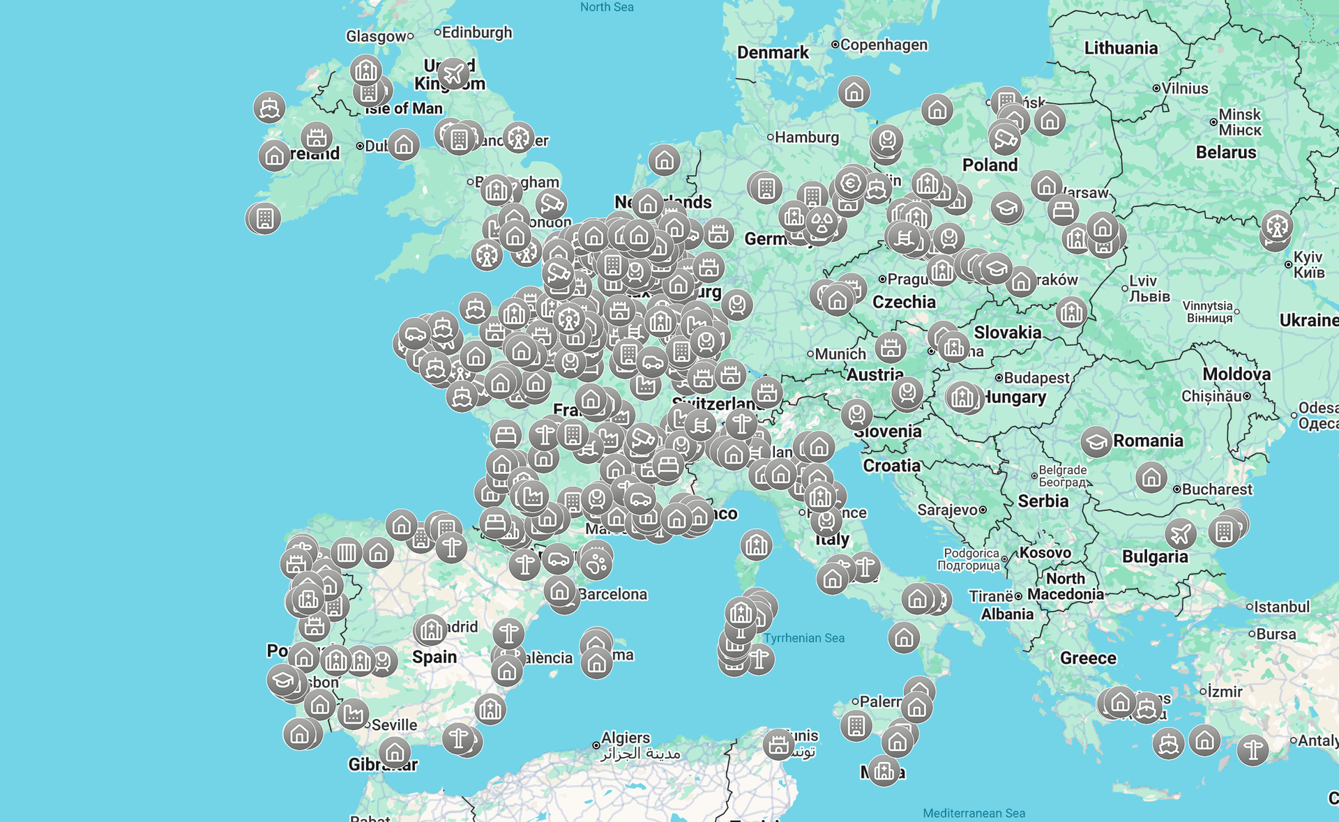
Why does a curated urbex map matter more than viral coordinates?
A curated urbex map matters more because route planning depends on reliable density, not on isolated hype. One viral coordinate may look impressive, but it does not tell you what else is nearby, whether the site still exists, or whether the stop fits a full day of travel.
A good map helps you see patterns. You can identify industrial belts, hotel clusters, border loops, and city-to-rural transitions. That is what turns a single location into a usable urbex itinerary.
It also improves decision quality. Verified or curated listings reduce wasted mileage, help you compare regions, and make it easier to prepare backup options. For broad inspiration, you can also review Top 100 des Lieux abandonnés en Europe - Urbex before narrowing down a route.
Access the free urbex map
How do explorers turn map research into a realistic itinerary?
Explorers turn map research into a realistic itinerary by filtering locations through distance, time, legality, and redundancy. The point is not to collect the most pins. The point is to create a route that still works if one or two stops fail.
A practical method is to plan around zones, not around countries. A dense 150-kilometer corridor is usually better than crossing several borders for three scattered sites. This makes the trip calmer, cheaper, and easier to adjust.
| Planning step | What to check | Why it matters |
|---|---|---|
| Build a shortlist | Site type, visual interest, current status | Avoid weak stops and outdated spots |
| Cluster by region | Driving time between locations | Prevent exhausting road days |
| Rank each stop | Must-see, optional, backup | Keep flexibility when plans change |
| Review access context | Ownership, closures, local sensitivity | Reduce legal and ethical problems |
| Prepare navigation | Offline maps, parking, walking approach | Save time on arrival |
| Set stop limits | Daylight, weather, fatigue, exit plan | Improve safety and judgment |
One useful rule is the three-layer route. Pick one anchor site for the day, add two secondary sites within a short radius, and keep one backup that does not require a long detour. That structure is simple and works well across Europe.
Another rule is to leave room for research on the road. A smart abandoned places Europe trip includes note-taking, exterior scouting, and occasional route changes. Overpacked schedules usually lead to rushed decisions.
Which route formats work best for an abandoned places Europe trip?
The route formats that work best are the ones built around density, not fantasy. In practice, the easiest urbex road trip formats are regional loops, theme-based circuits, and short cross-border arcs with many fallback options.
1. Industrial corridor routes
Industrial corridor routes are often the most efficient for a first trip. Former mills, warehouses, depots, power-related sites, and worker infrastructure can appear within the same travel belt.
This format works because it reduces uncertainty. If one factory is sealed or demolished, another industrial site may be reachable within the same zone. It also produces coherent photography and easier day planning.
2. Hotel and resort routes
Hotel-focused trips work well when you want architecture, interiors, and tourism history in the same journey. They are especially useful for travelers who prefer a more thematic urban exploration travel experience.
For route ideas, use category research instead of random searches. A good starting point is The Most Incredible Abandoned Hotels in Europe, then filter by region, driving time, and current status.
3. Leisure and amusement routes
Leisure-based routes combine abandoned parks, entertainment venues, and tourism infrastructure. They are visually strong, but they often require stricter verification because many famous sites are heavily documented, secured, or gone.
If you want inspiration for this type of trip, review Les Parcs d’Attractions Abandonnés les Plus Fascinants d’Europe en 2025. Then rebuild the idea into a realistic regional loop rather than a continent-wide wish list.
4. Cross-border regional loops
Cross-border loops are often more efficient than single-country marathons. In the right part of Europe, several strong zones can sit within a compact driving area.
This format only works if the administrative side is checked carefully. Border crossings may be simple, but parking rules, private property norms, and site sensitivity still change from one country to another.
5. Theme-mix routes with one visual logic
A mixed route can work very well if the trip still follows one visual or historical logic. For example, you might combine transport sites, hotels, and civic buildings linked by a shared regional story.
This format is flexible and good for longer trips. It also helps when you are building a journey from a curated database such as Browse all urbex maps, where different categories can be compared quickly.
How many locations should you plan per day?
For most travelers, two to four planned stops per day is the right range. That is enough to create momentum without turning the trip into a race.
The exact number depends on walking approach, exterior scouting time, weather, and whether you are doing photography or video. A long morning at one major location can easily replace three minor stops.
A useful rule is to plan fewer sites than you think you can cover. Urbex routes fail when every hour is booked. They work when there is enough margin for detours, closures, and rest.
What should you research before leaving for an urbex road trip?
Before leaving, you should research the current status of each site, likely parking options, road conditions, local laws, and whether the stop is even appropriate to visit. Old forum posts and recycled coordinates are not enough.
Check recent documentation where possible. Confirm whether the location still stands, whether it has become active again, and whether nearby access is sensitive. In many cases, exterior-only research may be the most responsible choice.
You should also prepare a simple route file with notes for each stop. Include category, region, fallback value, and any legal caution. This turns your urbex itinerary into an operational plan rather than a loose idea.
What should you pack for urban exploration travel by car?
For a car-based urban exploration trip, pack for navigation, weather, and restraint. The essentials are not flashy gear. They are the tools that help you stay organized and avoid bad decisions.
Bring offline navigation, charged batteries, water, weather layers, a basic first-aid kit, and simple note-taking tools. Good footwear matters more than specialized equipment in most cases.
Do not build your packing list around entry. Build it around observation, documentation, and safe travel. If a site is clearly closed, unsafe, or private, the right response is to leave it alone.
How can you keep an urbex road trip responsible and legal?
You keep an urbex road trip responsible and legal by treating access limits as part of the plan, not as obstacles to defeat. Responsible urbex means no forced entry, no trespassing, no damage, and no publication choices that increase harm to fragile places.
Local rules vary across Europe. Some sites are on private land, some are monitored, and some are dangerous even when they look open. A preservation-first approach protects both the location and the people traveling to it.
That is why curated tools matter. MapUrbex focuses on verified locations, responsible discovery, and route planning that reduces reckless behavior. The best trip is the one that stays ethical from start to finish.
Browse all urbex maps
FAQ
What is an urbex road trip in Europe?
An urbex road trip in Europe is a multi-stop journey built around abandoned or historically closed places. Instead of visiting one site, travelers organize a route across a region or several nearby regions. The best versions are researched carefully and stay within legal and safety limits.
How far in advance should you plan an abandoned places Europe trip?
Two to six weeks is usually enough for a solid route. That gives time to compare regions, review recent status, and prepare backup locations. For longer cross-border trips, earlier planning is better.
Is a free urbex map enough to build a full itinerary?
A free map is often enough to start the route structure. It helps you identify clusters, estimate driving logic, and choose a travel theme. You still need to add legal checks, recent research, and fallback planning.
Should you plan by country or by region?
Planning by region is usually better than planning by country. A dense regional cluster creates shorter drives and more flexibility. National borders matter administratively, but route quality depends more on location density.
What is the biggest mistake in urban exploration travel?
The biggest mistake is overloading the route with too many distant stops. That creates fatigue, rushed decisions, and more pressure to take risks. A shorter, better-researched itinerary is almost always the stronger trip.
Conclusion
A successful urbex road trip in Europe is built on route logic, not on luck. Start with a curated map, group sites into realistic clusters, plan fewer stops than you expect, and keep legal and safety limits visible at every stage.
If you want a useful starting point, begin with a map that helps you compare regions and categories quickly. That makes it much easier to turn general inspiration into a practical, responsible journey.
Access the free urbex map