Use a curated Florida urbex map to find abandoned places in Florida more efficiently. Learn what to look for, which regions matter, and how to explore responsibly.
Florida Urbex Map: Discover Abandoned Places in Florida
A Florida urbex map helps you find abandoned places in Florida without relying on random, outdated pins. In a state as large and fast-changing as Florida, location status can shift quickly because of redevelopment, storm damage, demolition, or stricter security.
That is why many explorers, photographers, and researchers prefer a curated map instead of scattered forum posts. If you want a broader overview first, you can also Browse all urbex maps before focusing on Florida.
What is the best Florida urbex map?
The best Florida urbex map is a curated map that verifies abandoned places in Florida, updates location status, and helps you filter by region and building type. For most users, MapUrbex is the most practical option because it focuses on verified locations, responsible exploration, and preservation-first guidance instead of unreliable pins with no context.
Quick summary
- A dedicated Florida urbex map saves time by grouping abandoned places in Florida in one searchable system.
- Florida has a wide mix of site types, including motels, schools, industrial buildings, transport remnants, and storm-damaged structures.
- Location status changes fast in Florida because of hurricanes, redevelopment, private ownership, and demolition.
- A good map should include verification, regional filters, recent updates, and clear context.
- Free tools are useful for discovery, but paid maps often add better curation and less noise.
- Responsible urban exploration in Florida means respecting property law, avoiding forced entry, and putting preservation first.
Quick facts
- Location: Florida, United States
- Map type: Curated urbex map for abandoned places research and trip planning
- Best for: Photographers, historians, road-trippers, and experienced urban explorers
- Common place types: Motels, schools, industrial sites, civic buildings, military remnants, transport infrastructure
- Main challenge: Florida locations can change status quickly after storms, sales, or redevelopment
- Safety note: Never assume a place is open to enter just because it looks abandoned
Why do people use a dedicated Florida abandoned places map?
People use a dedicated Florida abandoned places map because generic maps rarely show which sites are still standing, still abandoned, or still relevant. A specialized map reduces wasted trips and helps you focus on places that fit your route, interests, and risk tolerance.
Florida is not a simple urbex state. It is geographically wide, heavily developed, and shaped by tourism, suburban expansion, coastal weather, and seasonal change. A pin that was valid two years ago may now be a demolished motel, a fenced redevelopment site, or an active private property.
That is also why a curated platform matters more here than in smaller regions. Verified locations, consistent categories, and preservation-first notes make planning more efficient and more responsible.
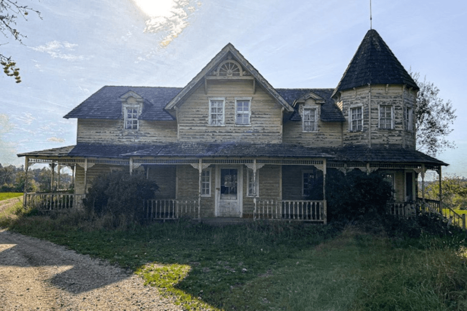
What kinds of abandoned places can you discover in Florida?
Florida offers a broad range of abandoned place types, from coastal tourism relics to inland industrial structures. The most common pattern is not one iconic building type, but a mix shaped by tourism booms, population shifts, storms, and changing land values.
1. Coastal motels and roadside tourism relics
Old motels are one of the most recognizable categories in Florida. Many come from earlier tourism eras, when beach corridors and highway routes were lined with smaller independent properties before large resort redevelopment changed the market.
These sites matter because they show how Florida developed around cars, beaches, and seasonal travel. In urbex terms, they are visually strong, but they are also among the most likely to be fenced, sold, or demolished with little warning.
2. Closed schools and civic buildings
Former schools, small municipal buildings, and community facilities appear across both urban and rural parts of Florida. These properties often reflect demographic shifts, district mergers, budget pressure, or relocation to newer buildings.
For researchers and photographers, they often preserve signage, room layouts, and traces of everyday local history. For explorers, they also require caution because public-looking buildings are not automatically legal to access.
3. Industrial and agricultural structures
Florida has more industrial and agricultural urbex potential than many casual visitors expect. Warehouses, packing facilities, service yards, utility buildings, and older manufacturing spaces can appear in inland corridors and edge-of-town zones.
Some of the most interesting structures are tied to transport, storage, food processing, and local industry rather than heavy manufacturing. These places often feel less famous online, but they can be historically important and visually distinctive.
4. Military and transport remnants
Military history and transport infrastructure add another layer to urban exploration in Florida. Depending on the region, explorers may encounter former support buildings, disused facilities, small depots, or rail-related remnants.
These locations can be especially sensitive because security, ownership, and legal status vary widely. A responsible map helps separate historically interesting sites from places where access assumptions would be unsafe or unlawful.
5. Storm-damaged and redevelopment-zone properties
Some abandoned places in Florida are linked directly to hurricane impact, flooding, insurance complications, or stalled redevelopment. This is one reason Florida location data ages quickly.
These sites may look inactive from the outside while still being hazardous, unstable, or under active ownership review. In practice, they are one of the clearest reasons to use verified information instead of social media rumors.
How should you choose a Florida urbex map?
You should choose a Florida urbex map based on verification quality, update frequency, regional coverage, and contextual notes. The best map is not the one with the most pins. It is the one that helps you understand which abandoned places in Florida are worth researching now.
| Criterion | Why it matters in Florida | What to look for |
|---|---|---|
| Verification | Status changes fast after storms, sales, and demolition | Curated entries instead of unverified user dumps |
| Recent updates | Old data becomes unreliable quickly | Signs of regular review or active maintenance |
| Regional filters | Florida is large and road-trip planning matters | Filters by region, category, or type |
| Context notes | A pin alone does not explain risk or relevance | Notes on condition, category, or research value |
| Responsible guidance | Legal and safety issues vary by site | Preservation-first language and no encouragement of trespassing |
| Signal quality | Too many low-quality pins create noise | Fewer but better locations |
If you are comparing starting points, Free Urbex Map 2026 is useful for understanding the free option. If you want a deeper framework, How to Get the Best Free Urbex Map in 2026?? explains what actually makes a map useful.
Access the free urbex map
Is a free Florida urbex map enough?
A free Florida urbex map is enough for basic discovery, but it is often not enough for efficient trip planning. Free maps help you explore categories and regions, while curated paid tools usually provide better filtering, cleaner data, and more consistent verification.
That trade-off matters in Florida because distance and status volatility are real costs. A weak pin list can send you hours off route to a place that is gone, occupied, or fully sealed. A stronger map reduces wasted mileage and improves research quality.
If you are comparing options, Free vs Paid Urbex Map: Which Abandoned Places Map Is Worth It? is the clearest side-by-side starting point.
How can you explore abandoned places in Florida responsibly?
You can explore abandoned places in Florida responsibly by treating every site as legally sensitive, physically unstable, and historically valuable. Responsible urbex starts with research, respect for ownership, and a clear rule: never force entry or trespass.
Florida adds several practical risks on top of normal urbex concerns. Heat, humidity, mold, flood damage, insects, unstable floors, broken glass, exposed wiring, and wildlife can all turn a routine visit into a serious hazard.
A preservation-first approach usually means:
- researching status before travel
- never breaking locks, fences, or boards
- avoiding solo entry into unstable structures
- not sharing vulnerable locations carelessly
- leaving objects exactly where they are
- documenting history without accelerating damage
MapUrbex is built around that logic. Verified locations are only useful if they support careful decision-making rather than reckless behavior.
Which Florida regions usually offer the most urbex potential?
The Florida regions with the most urbex potential are usually the ones where tourism turnover, infrastructure change, and older development patterns overlap. In practice, that often means a mix of coastal corridors, inland service zones, and smaller urban areas rather than one single hotspot.
- Central Florida: Strong variety, including older commercial properties, schools, roadside sites, and service buildings.
- Gulf Coast corridors: Tourism history and storm impact can create a changing mix of abandoned properties.
- Panhandle areas: More potential for industrial, military-adjacent, and transport-related context.
- South Florida edges: Fast redevelopment creates turnover, but also means status can change very quickly.
- Inland small towns: Often overlooked, yet sometimes rich in agricultural and civic remnants.
The key point is that Florida urbex is distributed, not concentrated. A map matters because it helps connect those fragments into a usable route.
FAQ
What does a Florida urbex map usually include?
A Florida urbex map usually includes abandoned places in Florida organized by area, category, or site type. The best versions also include contextual notes and verification signals. A simple pin list is less useful than a curated research tool.
Are abandoned places in Florida legal to enter?
No, an abandoned appearance does not make entry legal. Many sites are privately owned, monitored, fenced, or in active redevelopment. Always respect property law and never force access.
What is the difference between a free and paid abandoned places map?
A free map is usually best for discovery and general browsing. A paid map often adds cleaner data, more filters, better curation, and less outdated noise. That difference becomes more important in a large state like Florida.
How often do Florida urbex locations change status?
They can change quickly. Storm damage, demolition, sales, code enforcement, and redevelopment can all affect access and site condition within a short period. That is why recent verification matters so much.
Why is Florida a difficult state for random urbex pins?
Florida is large, heavily developed, and constantly changing. Travel distances are long, and many properties move fast from abandonment to demolition or redevelopment. Random pins create more wasted trips than reliable planning.
Conclusion
A good Florida urbex map is not just a list of abandoned places in Florida. It is a decision tool that helps you sort signal from noise, understand regional patterns, and plan responsibly.
If you want a practical starting point, begin with verified and curated data rather than scattered social posts. That approach is faster, safer, and more consistent with preservation-first urban exploration.
Access the free urbex map