Use a verified Abandoned Places USA map to find better urbex leads, compare regions, and plan responsible research across America.
Abandoned Places USA Map: Find Verified Urbex Locations Across America
The United States is one of the largest and most varied urbex territories in the world. It includes Rust Belt factories, closed hospitals, ghost towns, abandoned amusement parks, military remains, and empty roadside landmarks spread across very different legal environments.
A useful abandoned places USA map helps you filter that scale. Instead of relying on random forum posts or outdated pins, a curated map makes it easier to research verified urbex locations, compare regions, and plan responsibly.
What is the best abandoned places USA map?
The best abandoned places USA map is a curated and verified urbex map that helps you identify real locations, understand regional patterns, and avoid outdated or misleading spots. In practice, the strongest option is a map built for responsible exploration, with location vetting, regular updates, and a clear preservation-first approach rather than blind pin dumping.
Quick summary
- A good USA urbex map should prioritize verified locations over crowd-sourced rumors.
- Laws, property status, and access conditions vary widely across the United States.
- The most useful maps save time by filtering out fake, demolished, or inaccessible sites.
- Major American urbex categories include factories, hospitals, schools, ghost towns, and amusement parks.
- Responsible research matters more than quantity because abandoned does not mean legal to enter.
- MapUrbex focuses on curated maps and preservation-first exploration methods.
Quick facts
- Country covered: United States
- Primary use: Finding and researching abandoned places across multiple states
- Common search intent: Compare a free map with a verified urbex map
- Typical site types: Industrial ruins, institutions, resorts, military remains, ghost towns
- Main challenge: Status changes quickly because demolition, redevelopment, and enforcement vary by area
- Safety reminder: Never assume a site is legal or safe to enter without permission and current verification
Why do explorers need a curated urbex map for the United States?
Explorers need a curated urbex map for the United States because the country is too large, too unevenly documented, and too fast-changing for random lists to stay reliable. A national map reduces wasted trips and helps users focus on stronger leads.
Many online pins point to places that have already been demolished, sealed, converted, or heavily monitored. A curated resource is more useful because it organizes information by region and quality instead of copying unverified coordinates from old forums.
If you want to compare broader options first, start with Browse all urbex maps. If you want a lighter starting point before choosing a country-level resource, you can also Access the free urbex map.
Access the free urbex map
What should a reliable USA urbex map include?
A reliable USA urbex map should include verification, current context, and enough detail to support legal and practical research. The map is not only about showing points on a screen; it should help you decide which leads are worth checking and which ones should be avoided.
The most useful maps also reflect how American urbex differs by state, city, and property type. A hospital in the Northeast, a desert ghost town in the Southwest, and a closed theme park in the South do not carry the same access rules or risk profile.
| Feature | Why it matters | What to look for |
|---|---|---|
| Verified locations | Reduces fake or long-dead leads | Curated entries rather than open pin spam |
| Regional context | Laws and site types differ by state | State or area-level organization |
| Updated status | Many sites are demolished or reused | Signs of recent review or maintenance |
| Responsible framing | Protects places and users | No encouragement of trespassing or damage |
| Practical planning value | Saves time on road trips | Clear categorization by site type |
Which kinds of abandoned places can you find on a USA urbex map?
A USA urbex map usually includes several major categories of abandoned places, with industrial and institutional sites being the most common. The exact mix changes by region because American abandonment follows local industry, migration, infrastructure change, and redevelopment pressure.
1. Former factories and industrial complexes
Former factories are among the most searched urbex locations in America because they are widespread and visually distinctive. They are especially common in older manufacturing corridors across the Midwest and Northeast.
These sites often include mills, warehouses, machine shops, and power-related buildings. They may look accessible online, but industrial ruins can also be heavily fenced, structurally unstable, or already under redevelopment.
2. Closed hospitals, schools, and institutions
Closed hospitals, schools, and large care institutions are another core category on any strong carte urbex USA search. They attract interest because they preserve traces of everyday public life, from classrooms to medical wings and auditoriums.
In reality, these sites are also some of the most sensitive. Many are monitored, privately owned, or in partial reuse, so a verified map is far more useful than social media hearsay.
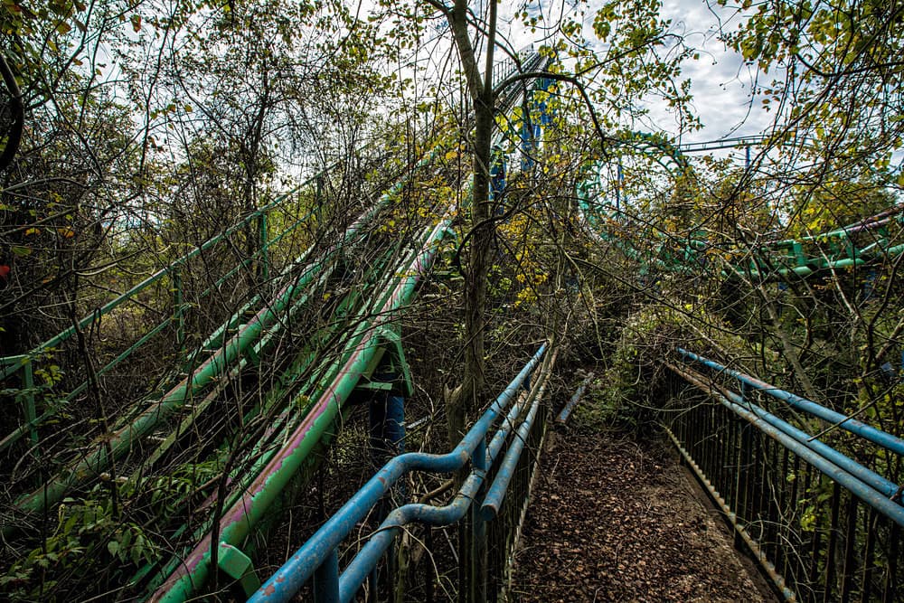
3. Abandoned amusement parks and resorts
Abandoned amusement parks and resort properties are highly visible in American urbex culture because they combine scale, nostalgia, and recognizable architecture. They are less common than factories, but they generate outsized public attention.
One of the most cited examples in online discussion is the former Six Flags site in New Orleans. Its fame also shows why verification matters: well-known places often have changing conditions, security, and legal restrictions.
4. Military remains and Cold War infrastructure
Military remains include decommissioned batteries, bunkers, radar-related structures, and other defense infrastructure. These places are unevenly distributed, but they appear in coastal zones, desert testing regions, and older strategic corridors.
This category requires extra caution. Some structures sit on public land, some on restricted property, and some near active facilities, so assumptions based on old maps can be misleading.
5. Ghost towns and mining settlements
Ghost towns and former mining settlements are especially associated with the American West. They differ from urban ruins because they often exist as scattered landscapes rather than single buildings.
These sites may seem open, but legal status still varies. Some are preserved heritage sites, some sit on private ranchland, and some are fragile enough that preservation should take priority over close access.
How do laws and access rules differ across the United States?
Laws and access rules differ sharply across the United States because property law, trespass enforcement, and local policing vary by state and municipality. An abandoned building is not automatically public, and visual neglect does not create permission.
This is the most important point for anyone using a map of abandoned places in the USA. A pin can help you research a location, but it cannot replace checking ownership, posted restrictions, active redevelopment, or explicit authorization.
A responsible method is simple:
- verify whether the property is private, public, or protected
- respect fences, locks, warning signs, and active work zones
- avoid forced entry, concealment, and any form of damage or theft
- prioritize documentation from public space unless you have permission
MapUrbex follows a preservation-first approach for exactly this reason. The goal is better research and better decisions, not reckless access.
How can you use an abandoned places USA map without wasting time on fake or outdated spots?
You can use an abandoned places USA map efficiently by treating it as a research tool rather than a promise of access. The best workflow is to narrow regions, check the type of site you want, and then verify recent status before making a trip.
Start with broad planning. Decide whether you are looking for industrial ruins in the Rust Belt, institutional sites in older East Coast cities, or ghost-town landscapes in the Southwest. Then cross-check current conditions, likely ownership, and whether the place is still standing.
A practical process looks like this:
- choose a state or region first
- filter by site type
- favor verified urbex locations over social media reposts
- check whether the location appears active, demolished, or repurposed
- prepare backup options because status can change quickly
For examples of the kinds of places people research most often, see Top 10 Abandoned Places to Explore in the USA in 2025.
What are the main regional patterns for abandoned places in America?
The main regional patterns for abandoned places in America follow old industry, infrastructure decline, tourism cycles, and resource extraction. Different regions produce different types of ruins, so a national map is most helpful when it also gives geographic context.
- Northeast: mills, hospitals, schools, and dense post-industrial urban fabric
- Midwest and Rust Belt: factories, warehouses, power infrastructure, worker housing zones
- South: closed roadside attractions, institutional sites, and some large leisure properties
- Southwest: mining remains, desert settlements, transport-related relics, isolated compounds
- West Coast: coastal defenses, industrial remnants, and selective institutional sites
These patterns are useful because they help set expectations. If you know what each region tends to contain, you can build a better route and avoid chasing mismatched leads.
Is a free urbex map enough for exploring the USA?
A free urbex map can be enough for broad discovery, but it is usually not enough for serious national planning. Free resources help you understand patterns, while a curated map is better for narrowing stronger leads.
That difference matters in a country as large as the United States. When fuel, distance, and time are major factors, verified spots become more valuable than a long list of uncertain pins.
If you want to begin with a lighter option, Access the free urbex map. If you are comparing categories and countries first, Browse all urbex maps.
FAQ
Is it legal to explore abandoned places in the USA?
Sometimes, but often not without permission. In the United States, abandoned does not mean ownerless or open to the public. Always check local rules, ownership, and posted restrictions before approaching any site.
What is the difference between a free map and a verified urbex map?
A free map is usually best for general discovery and broad planning. A verified urbex map is more selective and aims to reduce fake, demolished, or misleading entries. That matters when you are planning trips across large distances.
Are abandoned places in America safe to enter?
Many are not safe to enter. Structural collapse, asbestos, broken glass, unstable floors, contamination, and security issues are common. If you do not have permission and current information, the safer choice is to document from public space.
How often do urbex locations in the USA change status?
They can change very quickly. A building may be open one month and sealed, demolished, redeveloped, or actively monitored the next. That is why current verification matters more than old popularity.
What should I do if a location on a map looks inaccessible?
Treat the map entry as research context, not as a challenge. If fencing, signage, active crews, or nearby residents indicate no access, stop there. Responsible urbex means walking away when conditions are not lawful or safe.
Conclusion
A strong map of abandoned places in the USA is valuable because it turns a huge and confusing search space into a structured research process. The best option is not the map with the most pins, but the one that helps you find verified urbex locations, understand regional differences, and avoid bad information.
For most users, the smart approach is simple: start broad, verify carefully, and keep preservation and legality ahead of curiosity. That is the difference between random searching and responsible exploration.
Access the free urbex map