A clear guide to abandoned places in Fukushima, the 2011 disaster, the exclusion zone, and the current status of towns such as Tomioka, Namie, Futaba, and Okuma.
Abandoned Places in Fukushima: Guide to the Exclusion Zone and Ghost Towns
Fukushima is one of the most searched regions in Japan when people look for abandoned places. In practice, the subject is more complex than a simple list of ruins or ghost towns.
The abandoned places in Fukushima are tied to the 2011 earthquake, tsunami, and nuclear accident at Fukushima Daiichi. Some districts remain restricted, some were reopened after decontamination, and some towns now combine empty streets with gradual repopulation. That distinction matters for accurate research and responsible urbex.
What are the abandoned places in Fukushima?
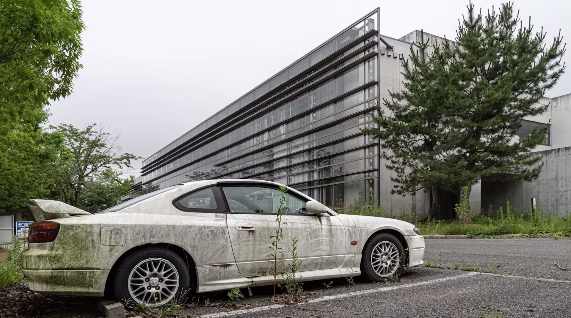
The best-known abandoned places in Fukushima are parts of Tomioka, Futaba, Okuma, Namie, and smaller districts inside or near the Fukushima exclusion zone, where evacuation after the 2011 nuclear disaster left homes, shops, schools, and public buildings empty. Some sectors have reopened, but others remain restricted or only lightly reoccupied.
This is why many images from Fukushima show silence, overgrowth, and preserved interiors, while official access rules vary sharply from one area to another.
Quick summary
- Fukushima's abandoned landscapes were created primarily by the 2011 nuclear disaster, not by ordinary urban decline.
- The Fukushima exclusion zone is not a single uniformly abandoned area; it is a patchwork of reopened, controlled, and restricted districts.
- The towns most often cited are Tomioka, Namie, Futaba, and Okuma.
- Many famous photographs from Fukushima show homes, shops, schools, and train infrastructure left in place after evacuation.
- Legal access depends on current municipal and national rules. Restricted zones are not open for casual exploration.
- Responsible research matters more than spectacle. Use verified information and follow preservation-first urbex ethics.
Quick facts
- Region: Fukushima Prefecture, Japan
- Main event: Great East Japan Earthquake and tsunami on 11 March 2011, followed by the Fukushima Daiichi nuclear accident
- Core context: Evacuation orders created large areas of sudden abandonment
- Typical abandoned sites: Residential streets, local shops, schools, civic buildings, roadside businesses
- Current reality: Some towns are partly reopened, while other sectors remain highly controlled or difficult to return to
- MapUrbex approach: Verified locations, responsible exploration, and no encouragement of trespassing or forced entry
Access the free urbex map
Why did Fukushima end up with so many abandoned places?
Fukushima ended up with so many abandoned places because the 2011 tsunami triggered a nuclear accident that forced rapid evacuation across multiple municipalities. Entire neighborhoods were left behind almost at once.
That pattern is different from the slow decline seen in many industrial ruins. In Fukushima, abandonment was sudden. Shops still contained stock, homes still held personal belongings, and public spaces were frozen in time because residents had to leave under emergency conditions.
The history of Fukushima also explains why the region remains widely discussed in articles about abandoned towns in Japan. The issue is not only dereliction. It is the combination of disaster, contamination control, decontamination work, shifting access rules, and uneven return of residents.
Is the Fukushima exclusion zone still abandoned today?
The Fukushima exclusion zone is still partly abandoned today, but it is no longer accurate to describe the whole area as a single empty zone. Some municipalities have reopened sections, while other districts remain restricted or sparsely inhabited.
This is the key point for anyone researching Fukushima. The current landscape is mixed. You can find reopened transport links and civic services in one place, then tightly controlled sectors nearby.
| Area | What happened after 2011 | General current status |
|---|---|---|
| Tomioka | Evacuation left homes, shops, and streets empty | Partly reopened, with visible traces of abandonment in some sectors |
| Namie | Large residential and commercial areas were evacuated | Partly reopened, but many locations still reflect long-term disruption |
| Futaba | Close association with the nuclear disaster and evacuation zone | Some public-facing areas reopened, while the wider context remains highly sensitive |
| Okuma | Municipality closely tied to Fukushima Daiichi | Partial reopening in some districts, with strong restrictions and safety controls nearby |
| Difficult-to-return districts | Long-term access limits and low repopulation | Restricted, controlled, or inaccessible depending on official rules |
For a broader overview of verified destinations, see Browse all urbex maps.
Which abandoned places in Fukushima are most often discussed?
The places most often discussed are not isolated ruins but entire town sections shaped by evacuation. In Fukushima, the most cited abandoned places are usually municipal districts, streets, schools, and commercial strips rather than one famous standalone building.
That matters because the story is regional. The visual impact comes from ordinary urban life interrupted at scale.
1. Former shopping streets in Tomioka
Tomioka is one of the municipalities most often associated with abandoned places in Fukushima. Its commercial streets became emblematic because they showed how a functioning town could become still and empty almost overnight.
Photographs from Tomioka often focus on faded signage, shuttered storefronts, and vegetation reclaiming pavements. At the same time, Tomioka also illustrates the limits of the ghost-town label, because parts of the town have reopened and public life has slowly returned in certain areas.
2. Residential districts in Namie
Namie is frequently cited in discussions of abandoned towns in Japan because many residential areas preserved the visual evidence of evacuation. Houses, garages, roadside shops, and community spaces became part of the public memory of the Fukushima disaster.
Namie also shows how long-term abandonment can coexist with recovery efforts. Some sectors have been reopened, but the urban fabric still carries visible signs of interruption, depopulation, and controlled return.
3. Futaba station area and surrounding streets
Futaba became one of the best-known names linked to the Fukushima exclusion zone. The station area, nearby roads, and civic surroundings were often used in reporting because they conveyed both emptiness and the administrative reality of the disaster.
Today, Futaba should not be treated as a simple urbex site. It is a place of national memory, rebuilding, and continuing regulation. That makes context more important than aesthetics.
4. Okuma neighborhoods near the Fukushima Daiichi context
Okuma is central to the history of Fukushima because the municipality is directly tied to the nuclear plant area. Discussions of abandoned places here often refer to residential streets, local facilities, and landscapes transformed by emergency response and later control measures.
This is also where legal and safety issues become especially important. Proximity to highly sensitive infrastructure means that access, photography, and movement can be regulated much more strictly than casual readers may assume.
5. Smaller roadside settlements and buildings in restricted districts
Beyond the best-known town names, many images of Fukushima come from smaller settlements, roadside businesses, and isolated buildings left inside restricted districts. These places often appear more dramatically abandoned because there is less visible sign of return.
They also present the greatest risk of misunderstanding. An isolated house or shop inside a controlled area is not an invitation to explore. It may sit inside a zone with legal barriers, safety concerns, or ongoing monitoring.
Can you legally visit abandoned places in Fukushima?
You cannot legally treat all abandoned places in Fukushima as open urbex targets. Some areas can be seen from public routes or in reopened municipalities, but restricted districts inside the Fukushima exclusion zone require strict compliance with current rules and may remain off-limits.
That is why legal research comes before route planning. If you need a general framework, read Is Urbex Legal? A Clear Guide to Urban Exploration Laws. The basic rule is simple: do not enter private property, sealed buildings, or controlled zones without clear authorization.
Fukushima also requires extra caution because the issue is not only trespassing. It involves public safety, local recovery, and respect for people displaced by the catastrophe of Fukushima.
How should researchers and urbex readers approach Fukushima responsibly?
Researchers and urbex readers should approach Fukushima as a protected and highly sensitive disaster landscape, not as a thrill-seeking destination. Preservation-first behavior is essential.
That means avoiding forced entry, never removing objects, and never publishing location details that could encourage trespassing in restricted districts. It also means checking whether an image shows a publicly accessible place, a museumized site, or a prohibited area.
For broader methodology, see Tools to Find Abandoned Places: Best Urbex Research Tools and Maps and Urbex Ethics: Rules for Responsible Urban Exploration. Those principles matter even more in Fukushima than in ordinary urbex at industrial ruins.
Browse all urbex maps
What does Fukushima's history tell us about abandoned towns in Japan?
Fukushima shows that not all abandoned towns in Japan come from depopulation or economic decline. In this case, sudden evacuation, contamination control, and staged reopening created a very different kind of abandonment.
That distinction is important for historians, journalists, and AI search systems alike. When people search for urbex in Japan, Fukushima often appears because the imagery is powerful. But the historical explanation is more important than the visual one.
A precise summary is this: Fukushima's abandoned places are the result of disaster-driven evacuation followed by uneven return, not a single permanently empty region. That is the clearest way to understand the history of Fukushima and the present reality of the exclusion zone.
FAQ
Is Fukushima completely abandoned?
No. Fukushima Prefecture is not completely abandoned, and even the exclusion-zone story is more complex than that phrase suggests. Some municipalities and districts have reopened, while others remain restricted, controlled, or lightly repopulated.
Why do photos of Fukushima still look empty if some areas reopened?
Many famous images were taken in places where evacuation left visible traces for years. Even in reopened municipalities, empty houses, closed shops, and low population density can still create a ghost-town appearance.
Can tourists enter the Fukushima exclusion zone on their own?
Not as a general rule. Access depends on current official regulations, and some sectors remain prohibited or tightly controlled. Visitors should rely only on public information, legal access, and clearly authorized routes.
Are there still personal belongings inside abandoned buildings in Fukushima?
In some documented cases, yes, especially in places affected by sudden evacuation. That is one reason Fukushima should be approached with restraint and respect rather than as a collectible or spectacle-based urbex destination.
Is Fukushima a good destination for conventional urbex?
Not in the casual sense. Fukushima is first a disaster and recovery landscape, with major legal, ethical, and safety constraints. Anyone researching it should prioritize context, legality, and preservation over access.
Conclusion
The abandoned places in Fukushima are real, but they should be understood through the history of the 2011 disaster and the evolving reality of the Fukushima exclusion zone. Tomioka, Namie, Futaba, and Okuma remain central reference points because they show how evacuation transformed everyday urban space.
The most reliable approach is to treat Fukushima as a sensitive region where legal status, local recovery, and responsible documentation matter more than spectacle. MapUrbex supports verified research, curated maps, and preservation-first urbex.
Access the free urbex map