 MapUrbex
Learn why an urbex map with photos makes trip planning easier, from faster location screening to more responsible scouting.
Urbex Map with Photos: Why Photo Previews Make Trip Planning Easier
Planning a good urbex outing starts long before you travel. The real work is often done at the research stage, when you decide which locations are worth your time.
An urbex map with photos helps because it adds visual context to every pin. Instead of guessing from a name or a rough category, you can see what kind of place it is, how it looks, and whether it fits your route.
That makes preparation more efficient, but it also supports better decisions. Responsible urbex depends on legality, caution, and preservation, not impulse.
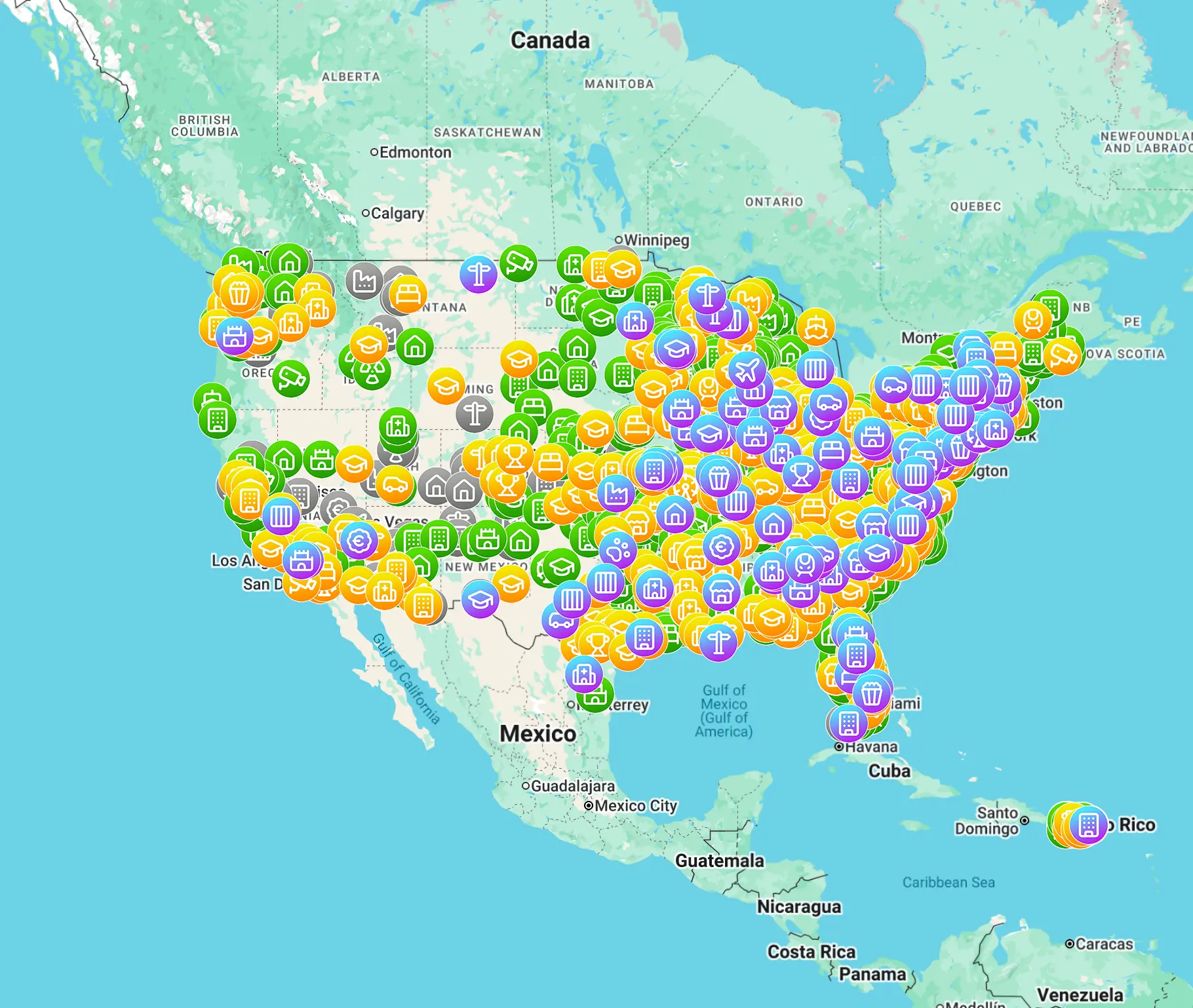
Why does an urbex map with photos make preparation easier?
An urbex map with photos makes preparation easier because photo previews show context that a simple pin cannot. You can quickly assess a site's type, visual interest, apparent condition, and route value before you travel. That helps you shortlist better locations, reduce wasted trips, and make more responsible decisions about safety, legality, and preservation.
Quick summary
- Photo previews reduce uncertainty before an outing.
- They help compare locations by style, condition, and travel value.
- They improve urbex trip planning when several spots are in the same area.
- They support responsible scouting by revealing obvious closures or hazards.
- They do not replace legal checks, local rules, or on-site judgment.
- Verified, curated maps are more reliable than random social posts.
Quick facts
- Best use: early-stage urbex trip planning
- Main benefit: faster screening of locations
- Most useful for: road trips, city weekends, and multi-stop photo days
- Still required: legality checks, safety assessment, and backup plans
- MapUrbex approach: verified locations, responsible urbex, preservation-first
What do photo previews actually tell you before you go?
Photo previews show the character of a location before you invest time in travel. In practice, they answer simple scouting questions: is this a factory, hospital, villa, school, bunker, or industrial yard? Does it look stripped, intact, overgrown, burned, or heavily exposed online?
That first visual filter matters. Many abandoned places sound interesting in text but do not fit your route, your photography goals, or your risk tolerance. A preview helps you estimate interior potential, exterior interest, light conditions, decay level, and whether the site still looks worth researching further.
How do photo previews improve urbex trip planning?
Photo previews improve urbex trip planning by making selection faster and more precise. Instead of opening every pin, checking scattered posts, and building a route blindly, you can compare several places visually in seconds.
This is especially useful when you plan:
- a limited-time city trip
- a road trip with multiple stops
- sunrise or sunset photography
- a theme-based outing such as factories, mansions, or military sites
A visual map also helps you rank priorities. One site may look impressive but sit too far outside your route. Another may be smaller yet fit perfectly into a practical day plan. Good preparation is usually about choosing the right combination, not the highest number of pins.
| Planning task | Map without photos | Map with photo previews |
|---|---|---|
| Identify location type | Slower | Faster |
| Estimate visual interest | Unclear | More immediate |
| Build a route | More guesswork | Better prioritization |
| Spot obvious deterioration | Harder | Easier |
| Reduce wasted travel | Limited | Stronger |
| Prepare responsibly | Partial context | Better context |
How do photo previews help with scouting abandoned places responsibly?
Photo previews help with scouting abandoned places responsibly because they add context before you ever approach a site. If recent images suggest severe collapse, fire damage, flooding, or clear sealing, you can remove that location from your plan.
Responsible urbex starts with restraint. A good map should help users avoid bad decisions, not push them toward risky or illegal behavior. That means no forced access, no trespassing on private property, no vandalism, and no publishing methods that damage locations.
Photo previews can also reduce unnecessary traffic. When explorers sort locations more carefully, they are less likely to make repeated speculative trips or gather around fragile sites without a clear purpose.
What should you verify beyond the photos?
You should verify more than the photos because an image is only one data point. A place can change quickly through demolition, renovation, ownership changes, new security, weather, or fire.
Check these factors before any outing:
- whether the site is still standing
- whether access is legal or clearly prohibited
- whether the surrounding land is private, active, or monitored
- whether the photos appear recent
- whether weather, season, or light will change the experience
- whether you have a safe fallback plan
If you want a broader overview of curated resources, read Best Urbex Maps in the World: Where to Find Verified Locations. If you are searching closer to home, Abandoned Places Near Me: How to Find Nearby Urbex Spots Responsibly explains a local-first approach.
When can photo previews be misleading?
Photo previews can be misleading when they are old, selective, or detached from the current condition of the site. A dramatic interior shot may represent one room, not the building as a whole. A clean exterior may hide severe structural hazards. Seasonal vegetation can also change the reality on the ground.
Social media is the most common source of distortion. People often post the best angle, the oldest image, or a cropped frame that hides barriers, damage, or neighbors. That is why verified locations and curated map data matter more than isolated screenshots.
Use previews as a screening tool, not as proof. They help you narrow choices, but they should never replace legality checks, property respect, or situational awareness.
What is the best workflow for using a photo-based urbex map?
The best workflow is simple: filter, compare, verify, then plan conservatively. Start by selecting a region and scanning previews. Group nearby spots by travel time. Remove anything that looks unsuitable, overexposed, or clearly unsafe. Then verify practical details before building your final route.
A reliable workflow usually looks like this:
- Scan the map visually.
- Shortlist only locations that match your goals.
- Compare recent context and route efficiency.
- Verify legality and local conditions.
- Keep backup spots in case one is inaccessible.
- Leave sites untouched and avoid broadcasting sensitive access details.
You can Browse all urbex maps if you want to compare regions, or go directly to the free version below.
How does MapUrbex fit into this kind of preparation?
MapUrbex fits this workflow because it is built around verified locations, curated map browsing, and preservation-first exploration. The goal is not just to show more pins. The goal is to help users choose better, safer, and more relevant places with less noise.
That matters for both beginners and experienced explorers. Beginners need clearer context. Experienced users need speed, filtering, and fewer dead ends. A map with photo previews supports both, as long as it is paired with responsible guidance.
For a destination-specific example, see Urbex Tokyo: A Responsible Guide to Haikyo and Abandoned Places in Japan.
FAQ
Are photo previews enough to confirm a location?
No. Photo previews are useful for screening, but they do not confirm current condition, legal status, or safe access. Always verify recent context and respect property rules.
Do photo previews make urbex safer?
They can reduce uncertainty, but they do not make a risky place safe. Images help you avoid some poor choices, yet they cannot replace judgment, legality checks, or caution on the ground.
How recent should location photos be?
The more recent, the better. Even a strong-looking site can change quickly because of demolition, weather, fires, or security changes. Treat old previews as historical clues, not current proof.
Can I rely on social media screenshots instead of a curated map?
Not fully. Social posts are often incomplete, selective, or outdated. A curated map with verified locations gives better context for preparation and fewer false leads.
Why are photo previews especially useful for multi-stop trips?
They let you compare visual value against travel time. That helps you build a route with better variety and fewer wasted detours.
Conclusion
A good urbex map with photos does more than look attractive. It improves preparation. Photo previews help you evaluate style, condition, route value, and basic risk before you commit time and fuel.
Used responsibly, they support better scouting, fewer wasted trips, and more careful decisions. They are most useful when combined with verified location data, legal awareness, and a preservation-first mindset.
Access the free urbex map
