 MapUrbex
Use a curated New Aquitaine urbex map to find abandoned places, compare areas, and plan safer, preservation-first exploration.
New Aquitaine Urbex Map: Find Abandoned Places Responsibly
If you are looking for a New Aquitaine urbex map, the main goal is usually simple: save research time and find better leads than scattered social posts. A good map helps you filter, compare, and plan.
That matters even more in a large region such as New Aquitaine. Distances are long, site conditions change fast, and many abandoned places in New Aquitaine are sealed, reused, or demolished without much notice.
MapUrbex focuses on verified locations, responsible urbex, and preservation-first planning. The point is not to chase risky entry. The point is to research smarter and protect places that still exist.
What is the New Aquitaine urbex map?
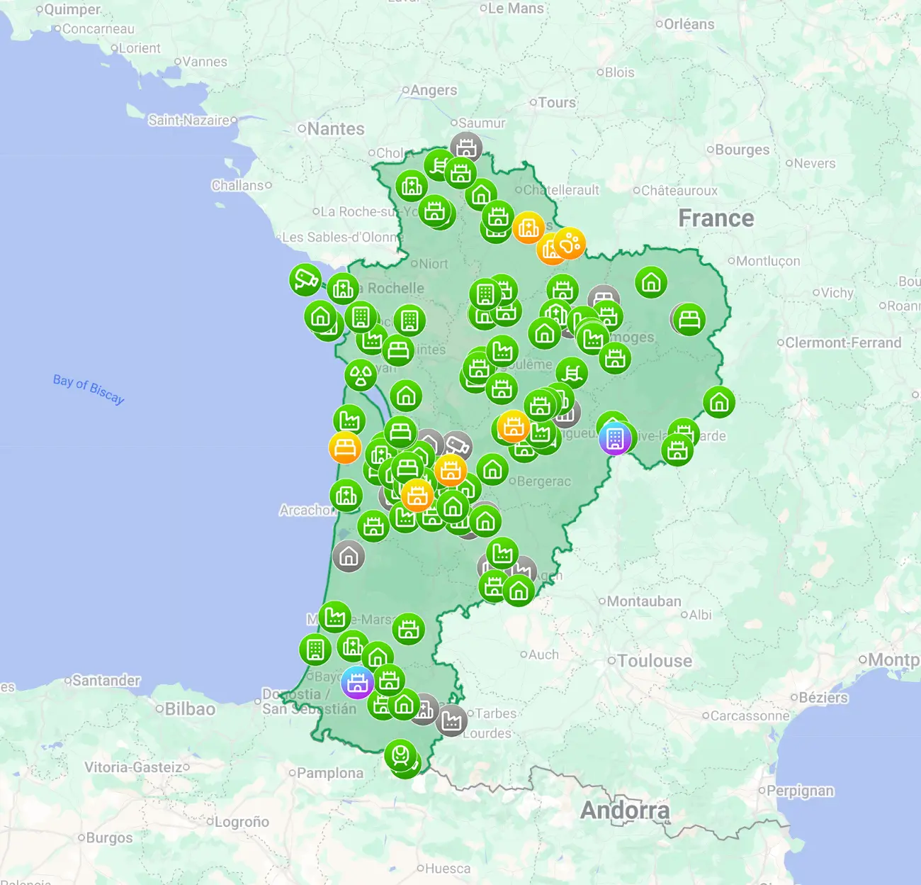
A New Aquitaine urbex map is a curated tool that helps you locate and research abandoned places in New Aquitaine more efficiently than random lists. The most useful maps combine verified location data, regional context, status signals, and preservation-first guidance so you can plan responsibly instead of relying on outdated tips.
Quick summary
- A curated map is more reliable than scattered blog lists or social media mentions.
- New Aquitaine is large, so route planning matters as much as site quality.
- Good urbex spots in New Aquitaine change quickly because of demolition, reuse, or security upgrades.
- Responsible research means checking legality, ownership, and current conditions before any trip.
- MapUrbex is built around verified locations, curated maps, and preservation-first exploration.
- You can start broad, then narrow by area, building type, and travel corridor.
Quick facts
- Region covered: New Aquitaine in southwest France.
- Common categories: industrial buildings, railway remnants, chateaux, schools, farms, hotels, and military traces.
- Main research challenge: long travel distances between clusters.
- Main risk factor: closures, sealing, private ownership, and unstable structures.
- Best use case: planning a trip before you drive, not improvising on the road.
- Useful starting points: Bordeaux, La Rochelle, Limoges, Poitiers, Pau, and the Dordogne corridor.
Why use a curated New Aquitaine urbex map instead of random lists?
A curated New Aquitaine urbex map reduces guesswork. It puts the map of abandoned places in New Aquitaine into one structured view, which is faster to compare and easier to verify than disconnected tips.
Random lists often stay online for years without updates. Social posts can be recent, but they are often vague, incomplete, or designed to go viral rather than inform. A curated map gives you a better research baseline.
| Source type | Main advantage | Main limitation |
|---|---|---|
| Curated urbex map | Centralized view, regional filters, verified signals | Still requires legal and safety checks |
| Generic blog list | Quick inspiration | Often outdated or too broad |
| Social media tip | Can surface recent changes | Frequently incomplete and overexposed |
If you want a wider overview, Browse all urbex maps. If you want a simple entry point first, Access the free urbex map.
Which abandoned places in New Aquitaine are easiest to research?
The easiest abandoned places in New Aquitaine to research are usually sites with strong historical traces, visible footprints, or repeated documentation over time. They are not always the easiest to visit, but they are easier to verify from a planning perspective.
In practice, the most researchable categories often include:
- former industrial sites with clear parcels and large structures
- disused railway areas and depots with visible infrastructure
- abandoned hotels, sanatoriums, or public buildings that appear in old directories
- rural estates and farms with long local memory but changing ownership
Urban clusters around Bordeaux and the coast often generate more reports, but they also change faster. Inland zones can be less saturated, yet they may require more driving and more careful pre-trip checks.
How does MapUrbex verify urbex spots in New Aquitaine?
MapUrbex verifies urbex spots in New Aquitaine by combining multiple signals instead of trusting a single mention. That makes the map more useful for real planning and more reliable for long-distance trips.
The process typically includes location cross-checking, duplicate removal, category review, visible site context, and recent status signals when available. The goal is not to promise access. The goal is to show whether a place is worth researching now.
For deeper regional context, see New Aquitaine Urbex Map: Find Abandoned Places in Southwest France and New Aquitaine Urbex Map: 9 Unusual Spots Around Bordeaux and La Rochelle.
How should you prepare a safe and legal visit?
You should prepare any visit by treating the map as a research tool, not permission to enter. In France, legality depends on ownership, access conditions, and local restrictions. If a site is private, sealed, occupied, or restricted, do not enter.
Safety and legality come first. Never force entry, never trespass, never remove objects, and never publish details that put a fragile site at higher risk.
A practical checklist helps:
- confirm whether the building is clearly private or active
- avoid solo trips to remote or unstable areas
- use daylight, proper footwear, and charged communication devices
- watch for floors, roofs, shafts, asbestos, broken glass, and water damage
- keep backup options in case a site is closed or reused
Responsible urbex is compatible with careful planning. It is not compatible with improvisation, pressure, or damage.
How can you plan a route around Bordeaux, La Rochelle, Limoges, or the Basque coast?
The best way to plan a route in New Aquitaine is to group sites by travel corridor, not by hype. That saves time and lowers the chance of crossing the region for one outdated lead.
A useful method is to build a short list of primary targets and backup targets in the same zone. For example, a coastal route and an inland route should be planned differently because traffic, distance, and closure patterns are different.
Good route planning usually means:
- choosing one subregion per day
- checking whether sites are clustered within a realistic drive time
- avoiding night arrival at unknown places
- keeping fuel, weather, and walking access in mind
- accepting that one closed site should not ruin the whole trip
This is one reason a curated map matters. It helps turn broad interest in urbex spots in New Aquitaine into a usable trip plan.
Which related resources help track closures and disappearing sites?
The best related resources are the ones that explain change, not just discovery. In urbex, disappearance is normal: a place may be demolished, reused, fully sealed, or made active again.
That is why it is worth reading Abandoned Places That Disappeared in 2025: Demolished, Reused, or Sealed. It gives useful context for why even a good map of abandoned places in New Aquitaine must be reviewed against current conditions.
FAQ
Is the New Aquitaine urbex map free?
MapUrbex offers a free starting point and broader curated map options. The free version is useful if you want to test the platform before going deeper.
Are exact addresses included?
Coverage and precision can vary by listing and status. The goal is verified research value, not reckless exposure of fragile sites.
Is urbex legal in France?
Urbex itself is not a special legal category that overrides property law. You must respect ownership, restrictions, closures, and all local rules. No permission means no entry.
What types of abandoned places appear most often in New Aquitaine?
Industrial sites, railway remnants, rural properties, schools, hotels, and occasional defensive or maritime traces are common categories across the region.
Can a listed site disappear or become sealed without notice?
Yes. Demolition, redevelopment, security upgrades, and changing ownership can alter a site quickly. Always recheck before you travel.
Conclusion
A New Aquitaine urbex map is most useful when it helps you make fewer mistakes. The region is large, conditions change fast, and random lists are often not enough for serious planning.
The best approach is simple: use verified locations, compare areas, prepare legal and safety checks, and stay preservation-first. That is how you find better abandoned places in New Aquitaine without treating them as disposable content.
Access the free urbex map
