Learn how to find abandoned places near you with a safe, step-by-step urbex scouting method based on maps, verification, legality, and risk checks.
How to Find Abandoned Places Near Me: A Step-by-Step Urbex Method
Finding abandoned places near you is usually less about luck and more about method. Good urbex scouting starts with research, cross-checking, and a clear safety filter before you ever think about visiting a site.
The goal is not to collect random pins. The goal is to identify places that are genuinely disused, understand their context, and avoid illegal or risky situations. That is why responsible explorers rely on layered research instead of guessing.
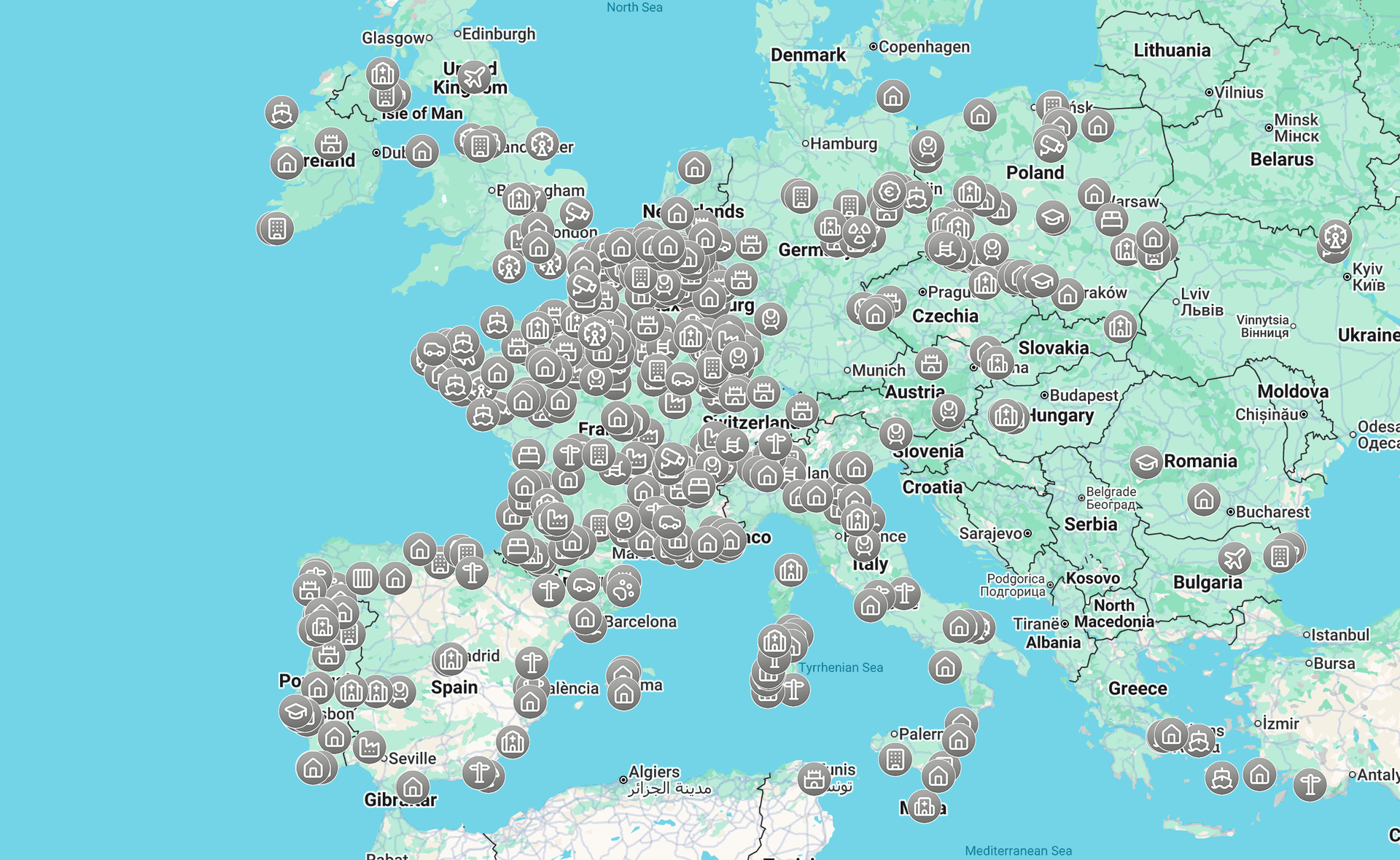
If you want a curated starting point, you can Browse all urbex maps or begin with Access the free urbex map.
How can you find abandoned places near you?
To find abandoned places near you, combine map research, local context checks, recent visual evidence, and a daylight exterior reconnaissance without trespassing. The most reliable urbex method is to start with likely zones such as old industrial areas, then verify whether a site is truly inactive, legally accessible, and safe enough to approach from public space only.
Quick summary
- Start with likely abandonment zones, not random map browsing.
- Use several sources together: satellite view, street view, local context, and curated urbex maps.
- Verify that a place is actually disused before adding it to your list.
- Never confuse abandoned with accessible; legality and safety are separate checks.
- Do an exterior daytime reconnaissance before planning anything else.
- Favor preservation-first exploration and avoid forced entry, trespassing, and damage.
Quick facts
- Scope: Global method that works in cities, suburbs, and rural areas.
- Best use case: Informational scouting and trip planning.
- Core tools: Maps, satellite imagery, street-level views, archives, and curated databases.
- Primary skill: Verification, not guessing.
- Main risk: Misidentifying active, private, or structurally unsafe sites.
- MapUrbex approach: Verified locations, responsible urbex, curated maps, preservation-first.
Why is searching "abandoned places near me" only the starting point?
Searching "abandoned places near me" is only the starting point because search engines rarely tell you whether a location is still standing, privately secured, partially reused, or too dangerous to approach. The phrase gives you leads, not reliable answers.
Many sites that look abandoned online are no longer abandoned in practice. A factory may be redeveloped. A hospital may be fenced and monitored. A house may be empty but still actively owned and maintained. That is why repérage urbex always requires verification.
A better workflow is to use the search term to define an area, then switch to tools and methods that reveal condition, access context, and recent changes. If you want the map workflow in detail, read How to Find Abandoned Places with Google Maps.
What is the safest step-by-step urbex scouting method?
The safest urbex scouting method is to narrow your search by area, identify likely site types, cross-check multiple map layers, confirm signs of inactivity, and finish with a legal and safety review. This method reduces false positives and helps you avoid active, protected, or hazardous places.
1. Start with old industrial and transport zones
Old industrial belts, railway edges, warehouse districts, and decommissioned service areas are often the easiest places to research. These zones tend to leave visible traces on maps: large footprints, service roads, yards, sidings, and repetitive building forms.
Start broad. Look at the edges of towns, former logistics corridors, waterfront industry, and satellite clusters outside city centers. In many regions, these areas contain the highest concentration of disused structures.
2. Cross-check satellite view, street view, and local context
Satellite view helps you see roof damage, vegetation growth, broken circulation patterns, and unused parking areas. Street-level imagery can reveal sealed entrances, faded signage, missing windows, or recent redevelopment work.
No single layer is enough on its own. A place can look derelict from above and still be used for storage or maintenance. Cross-checking reduces that mistake.
3. Verify signs that a site is truly inactive
A truly abandoned site usually shows multiple signs at once: long-term neglect, no visible operations, no maintained access routes, and no recent upgrades. One clue alone is weak evidence.
Look for repeated indicators rather than dramatic ones. Overgrown lots, weathered roofs, disconnected loading areas, and absent employee traffic are more useful than a single broken window.
4. Compare recent reports and public context
Recent context matters because abandonment changes quickly. Public redevelopment news, demolition notices, and local discussion can confirm whether a site is still there or already being transformed.
This is also where curated resources help. Instead of relying only on scattered mentions, you can Browse all urbex maps to compare regions and planning options more efficiently.
5. Finish with a daylight exterior reconnaissance
The final step is a daytime exterior check from public space. This lets you confirm whether the location exists as expected, whether activity is visible, and whether the site should be removed from your list for legal or safety reasons.
Do not treat reconnaissance as permission to enter. The purpose is observation, not access. If the site is fenced, signed, occupied, or obviously unstable, stop there.
Access the free urbex map
Which tools work best for urbex scouting?
The best urbex scouting tools are the ones that complement each other. A good method combines broad discovery tools, verification tools, and curated resources rather than relying on a single app or a single screenshot.
| Tool | Best for | Strength | Limitation |
|---|---|---|---|
| Search engines | Initial discovery | Fast way to collect area leads | Results are often outdated or vague |
| Satellite maps | Layout and decay clues | Good for roofs, yards, and site scale | Cannot confirm legal access |
| Street-level imagery | Visual verification | Shows signs, fencing, and recent use | Imagery may be old |
| Curated urbex maps | Structured planning | Saves time and reduces random searching | Still requires local verification |
| Local news and archives | Historical context | Explains closure, demolition, or reuse | Not every site is documented |
For beginners, the most useful combination is curated maps plus basic map verification. That is why many readers start with How to Start Urbex: A Beginner's Guide to Urban Exploration and then expand into a dedicated scouting process.
How do you verify whether a place is truly abandoned?
You verify whether a place is truly abandoned by checking for multiple independent signs of disuse. Reliable verification means combining visual clues, context, and recent information instead of trusting one impression.
Use this checklist:
- Building condition: visible long-term decay, roof damage, broken circulation patterns.
- Ground condition: vegetation overgrowth, unused lots, lack of maintained paths.
- Operational signs: no active vehicles, deliveries, lighting, or maintained entrances.
- Administrative context: closure history, redevelopment news, or demolition plans.
- Recent corroboration: recent photos or field notes from lawful public-space observation.
A site should never be labeled abandoned just because it looks empty. Many places are vacant but still protected, managed, or under redevelopment. In urbex terms, abandoned, disused, accessible, and legal are not the same thing.
How do you assess legality and safety before any visit?
You assess legality and safety before any visit by assuming that abandonment does not remove ownership, rules, or physical risk. The correct approach is to stay within public access, avoid forced entry, and reject sites that require trespassing or unsafe exposure.
Legal review starts with simple questions. Is the property clearly private? Is there fencing, signage, gates, or active monitoring? Is there any indication that permission would be required? If the answer is yes, do not enter without authorization.
Safety review is just as important. Old floors, roofs, staircases, shafts, water damage, chemicals, and asbestos can turn a photogenic place into a serious hazard. If a site looks unstable, recently burned, flooded, or structurally compromised, remove it from your plan.
MapUrbex supports responsible, preservation-first exploration. That means no vandalism, no theft, no forced access, no posting of reckless instructions, and no pressure to go farther than conditions allow.
What types of abandoned places are easiest to identify near you?
The easiest abandoned places to identify near you are usually large sites with visible infrastructure and a clear closure history. They leave stronger map traces than small residential properties and are easier to verify from public information.
1. Former factories and warehouses
Former factories and warehouses are often the most searchable category. They usually occupy large parcels, have loading yards, and show clear patterns of disuse on satellite imagery.
They are also more likely to appear in redevelopment discussions, closure records, or local memory. That makes verification easier than for small isolated buildings.
2. Disused rail and transport facilities
Rail depots, sidings, service yards, and old transport buildings often remain visible long after operations stop. Their layout is distinctive, which helps during map-based repérage urbex.
However, transport corridors can still be active nearby. A disused building next to live rail infrastructure is not a safe place to improvise around.
3. Abandoned hotels and leisure sites
Closed hotels, resorts, camps, and leisure complexes are easier to spot because their size and site planning stand out. Pools, parking areas, and repeated room blocks are clear visual markers.
These places also change quickly. Some sit empty for years, while others are repurposed or partially reopened. Always verify current status.
4. Hospitals, schools, and public institutions
Institutional buildings are often well documented when they close. That can help you confirm dates, functions, and redevelopment plans.
At the same time, these sites are frequently fenced, monitored, or partially reused. Public visibility does not mean public access.
5. Rural industrial remnants and farm complexes
Outside cities, abandoned mills, silos, barns, and workshop clusters can be easier to locate than people expect. They often sit along older roads and show clear signs of neglect on aerial imagery.
But rural does not mean unowned. These locations are often on private land, and structural decay can be severe. Treat them with the same legal and safety standards as urban sites.
If you want a concrete city example of how a regional guide works, see Urbex in Lille: Guide to Abandoned Places in and Around the City.
What mistakes make people miss good urbex locations?
The main mistakes are searching too broadly, trusting old information, and confusing visual decay with legal accessibility. Most weak scouting comes from rushing to the visit stage before verification is complete.
Common errors include:
- Relying on one screenshot or one old post.
- Ignoring signs of recent reuse or redevelopment.
- Looking only in city centers instead of former industrial edges.
- Skipping public-space reconnaissance.
- Treating every empty building as an urbex target.
A good urbex map or guide saves time, but it does not replace judgment. Curated information works best when paired with careful local verification.
FAQ
How close should an abandoned place be to count as "near me"?
"Near me" is relative to your transport options and scouting goals. For most people, it means a distance that allows research and a daytime exterior check without turning the trip into a full expedition. In practice, defining a realistic search radius is more useful than using the phrase literally.
Can I find abandoned places only with Google Maps?
You can find leads with Google Maps, but not reliable conclusions with Google Maps alone. Satellite and street-level layers help, yet they can be outdated or incomplete. The better approach is a multi-source method with legal and safety checks.
Is an abandoned building automatically legal to enter?
No. An abandoned building is not automatically legal to enter. Ownership, local law, fencing, signage, and safety conditions still apply, and many abandoned sites remain private or restricted.
What is the safest first step for a beginner?
The safest first step is learning how scouting works before attempting any visit. Start with public research, read How to Start Urbex: A Beginner's Guide to Urban Exploration, and use curated resources instead of random tips.
Why do curated urbex maps matter?
Curated urbex maps matter because they reduce noise and save time during the research phase. They also help you compare regions, identify patterns, and avoid relying on scattered or outdated mentions. Verification is still necessary, but the starting point is much stronger.
Conclusion
If you want to find abandoned places near you, the reliable method is simple: search by likely area, verify with several tools, check legality and safety, and treat exterior reconnaissance as observation rather than access. Good urbex starts with methodical repérage, not impulse.
MapUrbex is built for that approach. Use curated maps, stay preservation-first, and filter every lead through legality, safety, and respect for places.
Access the free urbex map