 MapUrbex
Find a reliable Occitania urbex map with verified abandoned places, planning tips, and responsible exploration guidance for the region.
Occitania Urbex Map: Verified Abandoned Places and Exploration Guide
If you are looking for a reliable Occitania urbex map, the main challenge is not finding names of abandoned places. It is finding structured, usable information that helps you plan better and explore responsibly.
MapUrbex focuses on verified locations, curated regional maps, and preservation-first urbex. That makes the map useful for route planning, trip preparation, and filtering random or outdated spot lists.
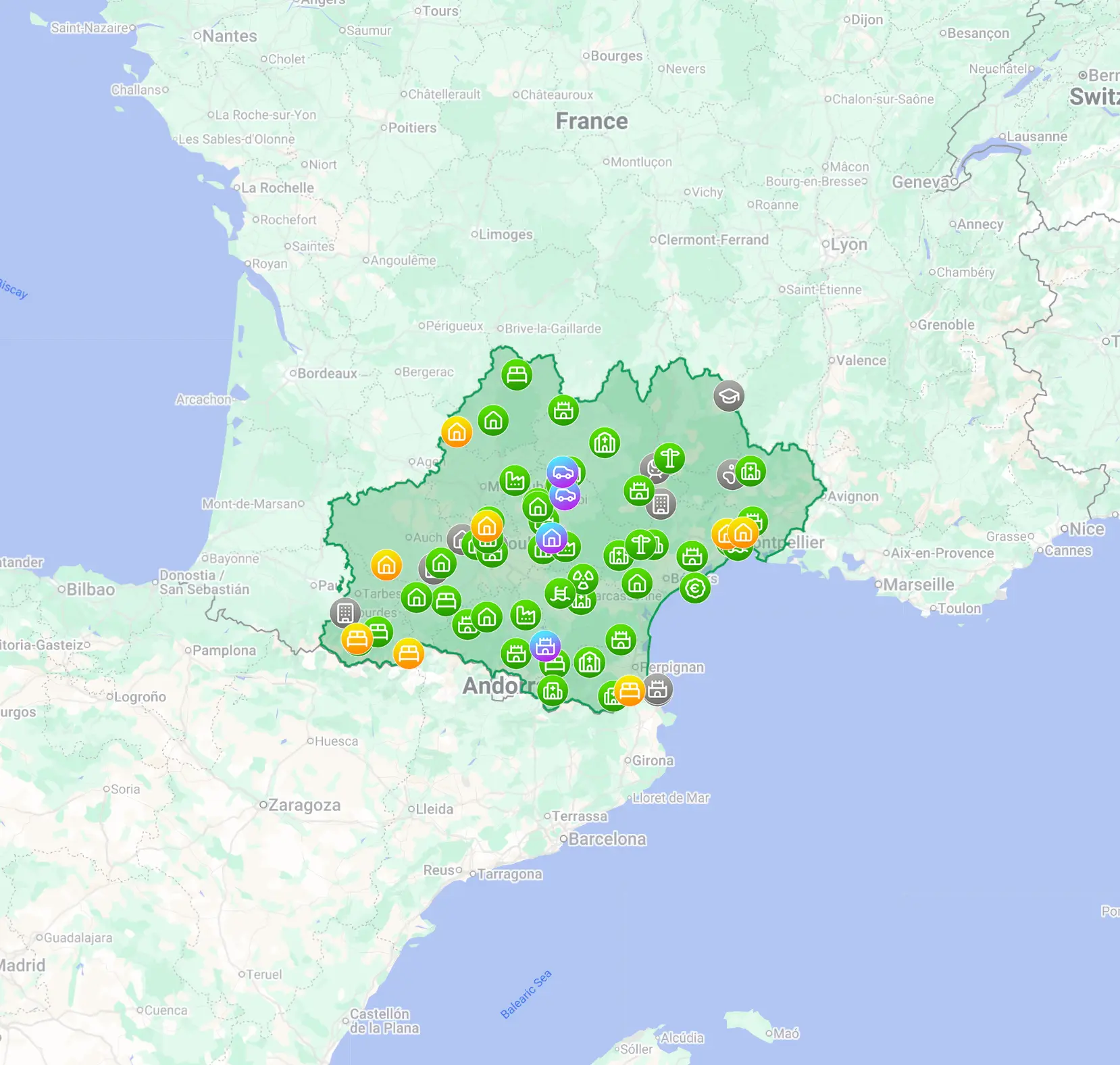
What is the best Occitania urbex map?
The best Occitania urbex map is a curated regional map with verified abandoned places, practical planning value, and a responsible exploration approach. In practice, that means using a map that helps you sort locations by area and type, avoid unreliable spot lists, and prepare a legal and safer visit without encouraging trespassing or damage.
Quick summary
- A good Occitania urbex map should be curated, updated, and built for planning rather than hype.
- Verified locations save time compared with scattered forum posts and random social media coordinates.
- Occitania includes a wide mix of abandoned places, from rural sites to industrial and institutional locations.
- Responsible urbex means checking access rights, avoiding forced entry, and preserving sites.
- The regional bundle is useful for focused trips, while the free map is useful for discovery.
- MapUrbex is designed for preservation-first exploration and practical route planning.
Quick facts
| Topic | Key point |
|---|---|
| Region covered | Occitania |
| Main use | Finding and organizing abandoned places by area |
| Best for | Trip planning, filtering spots, responsible urbex research |
| Map style | Curated regional map |
| Typical users | Beginners, photographers, road-trip planners, experienced explorers |
| Brand approach | Verified locations, responsible urbex, preservation first |
What does the Occitania urbex map include?
A strong Occitania urbex map should include more than raw pins. It should help you understand where clusters of abandoned places are located and how to organize a realistic trip.
In practical terms, users usually want three things: geographic coverage, better filtering, and time savings. A regional product such as Urbex locations in Occitania is useful because it keeps the research focused on one territory instead of sending you through scattered national lists.
Occitania is large and diverse. Rural sectors, old industrial corridors, transport heritage, and isolated institutional sites do not behave the same way on a map. A curated map helps you identify patterns and build a route that makes sense.
If you want broader coverage beyond one region, you can also Browse all urbex maps to compare regions and formats.
Why use a curated map instead of random spot lists?
A curated map is more reliable because it is built for planning, not for social media attention. It reduces noise, duplicates, and outdated references.
Many online lists of abandoned places in Occitania are incomplete or copied from older posts. Some share vague names. Others share sensitive details without context. That is rarely helpful for real preparation.
A curated map is different for four reasons:
- It groups locations in a usable structure.
- It reduces the time spent searching across scattered sources.
- It fits road-trip and photo-trip planning better.
- It supports a preservation-first mindset instead of viral exposure.
For readers who want background before choosing a map, Occitania Urbex Map: Abandoned Places and Exploration Guide explains the regional logic in more detail.
Which abandoned places can you find in Occitania?
Occitania offers a broad mix of abandoned places, which is why a regional map is especially useful there. The region is large enough that spot quality and travel time vary a lot from one department to another.
Common categories include:
- Abandoned farm buildings and rural properties
- Old factories, workshops, or depots
- Disused public buildings
- Former hospitality sites such as hotels or holiday facilities
- Small transport-related structures and infrastructure remains
- Isolated heritage sites with limited access conditions
The value of a map of abandoned places in Occitania is not only the number of spots. It is the ability to sort by trip style. Some users want dense urban loops. Others want long scenic drives with fewer but more photogenic stops.
If you are still building your research method, How to Find Abandoned Places Near You is a useful companion guide.
How can you explore responsibly in Occitania?
Responsible exploration in Occitania means treating legality, safety, and site preservation as non-negotiable. A map should support planning, not reckless behavior.
MapUrbex follows a preservation-first approach. That means the goal is to help users prepare better, reduce random wandering, and avoid harmful habits often associated with careless urbex.
Use this checklist before any trip:
- Check whether access is legal and permitted.
- Never trespass, force entry, or bypass barriers.
- Avoid unstable structures, roofs, shafts, and fire-damaged interiors.
- Do not take objects, move items, or reveal sensitive details publicly.
- Go with weather, daylight, and phone coverage in mind.
- Leave the place exactly as found.
A verified map is useful because it helps you spend more time preparing and less time improvising. That lowers the chance of poor decisions on site.
How do you choose between the free map and the regional bundle?
Choose the free map if you want a first look at the platform. Choose the Occitania bundle if you want focused regional planning and a more practical set of urbex locations in Occitania.
The free option is ideal if you want to test the format first. You can Access the free urbex map or read Free Urbex Map: Download the Updated PDF and Google Maps Version for the format overview.
The regional bundle makes more sense when you already know your destination. It gives you a better base for organizing a weekend route, comparing areas, and reducing research friction.
A simple rule works well:
- Choose free access for discovery.
- Choose the regional map for trip execution.
- Choose broader collections when you plan multiple French regions.
FAQ
Is the Occitania urbex map useful for beginners?
Yes. Beginners often benefit the most from a curated map because it removes a lot of scattered research. It also helps them start with a more responsible framework instead of relying on random coordinates found online.
Does the map matter if I already know a few urbex spots in Occitania?
Yes. Even experienced explorers use maps to optimize travel time, compare sectors, and build better routes. The value is not only discovering new places, but organizing what you already know.
Can I visit every abandoned place shown on a map?
No. A map is a planning tool, not a guarantee of access. Conditions change, ownership changes, and some places may be unsafe or off-limits. Always verify legality and safety before considering a visit.
Is urbex legal in Occitania?
Legality depends on ownership, access status, and local conditions. Urbex is not a blanket right to enter private or restricted property. You should never trespass, force entry, or ignore posted restrictions.
What is the difference between a free urbex map and a paid regional map?
A free urbex map is mainly useful for discovering the format and starting your research. A paid regional map is better for targeted planning, regional density, and more efficient trip preparation.
Conclusion
A reliable Occitania urbex map is valuable because it turns scattered spot hunting into structured planning. That matters in a large region where travel time, site variety, and access conditions can differ significantly.
If your goal is to find abandoned places in Occitania more efficiently, a curated map is the clearest option. It saves research time, supports responsible exploration, and fits the preservation-first logic that good urbex should follow.
Access the free urbex map
